You are here: Home > Network List > US - United States National Seismic Network Stations List
> Station EGMT Eagleton, Montana, USA > Earthquake Result Viewer
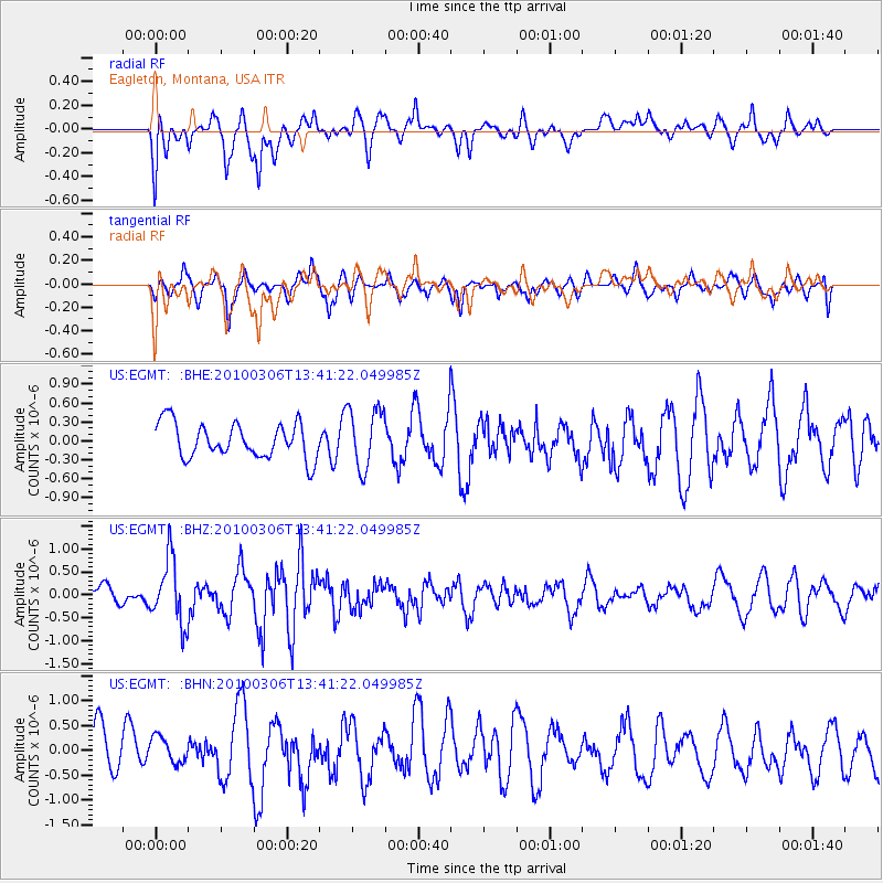
EGMT Eagleton, Montana, USA - Earthquake Result Viewer
*The percent match for this event was below the threshold and hence no stack was calculated.
| Earthquake location: |
Kuril Islands |
| Earthquake latitude/longitude: |
44.2/147.6 |
| Earthquake time(UTC): |
2010/03/06 (065) 13:31:12 GMT |
| Earthquake Depth: |
53 km |
| Earthquake Magnitude: |
5.7 MW, 5.1 MS, 5.4 MB, 5.6 MW |
| Earthquake Catalog/Contributor: |
WHDF/NEIC |
|
| Network: |
US United States National Seismic Network |
| Station: |
EGMT Eagleton, Montana, USA |
| Lat/Lon: |
48.02 N/109.75 W |
| Elevation: |
1055 m |
|
| Distance: |
65.8 deg |
| Az: |
45.894 deg |
| Baz: |
309.675 deg |
| Ray Param: |
$rayparam |
*The percent match for this event was below the threshold and hence was not used in the summary stack. |
|
| Radial Match: |
61.275707 % |
| Radial Bump: |
400 |
| Transverse Match: |
65.93317 % |
| Transverse Bump: |
400 |
| SOD ConfigId: |
299721 |
| Insert Time: |
2010-04-26 17:44:25.796 +0000 |
| GWidth: |
2.5 |
| Max Bumps: |
400 |
| Tol: |
0.001 |
|
Signal To Noise
| Channel | StoN | STA | LTA |
| US:EGMT: :BHZ:20100306T13:41:22.049985Z | 2.5460389 | 7.0758875E-7 | 2.779175E-7 |
| US:EGMT: :BHN:20100306T13:41:22.049985Z | 0.5929565 | 2.8483484E-7 | 4.8036384E-7 |
| US:EGMT: :BHE:20100306T13:41:22.049985Z | 1.7331212 | 4.7950397E-7 | 2.766708E-7 |
| Arrivals |
| Ps | |
| PpPs | |
| PsPs/PpSs | |


