You are here: Home > Network List > IU - Global Seismograph Network (GSN - IRIS/USGS) Stations List
> Station PMG Port Moresby, New Guinea > Earthquake Result Viewer
PMG Port Moresby, New Guinea - Earthquake Result Viewer
| Earthquake location: |
Java, Indonesia |
| Earthquake latitude/longitude: |
-6.7/107.1 |
| Earthquake time(UTC): |
2022/12/08 (342) 00:50:55 GMT |
| Earthquake Depth: |
107 km |
| Earthquake Magnitude: |
5.8 mww |
| Earthquake Catalog/Contributor: |
NEIC PDE/us |
|
| Network: |
IU Global Seismograph Network (GSN - IRIS/USGS) |
| Station: |
PMG Port Moresby, New Guinea |
| Lat/Lon: |
9.40 S/147.16 E |
| Elevation: |
90 m |
|
| Distance: |
39.7 deg |
| Az: |
96.607 deg |
| Baz: |
270.799 deg |
| Ray Param: |
0.07447284 |
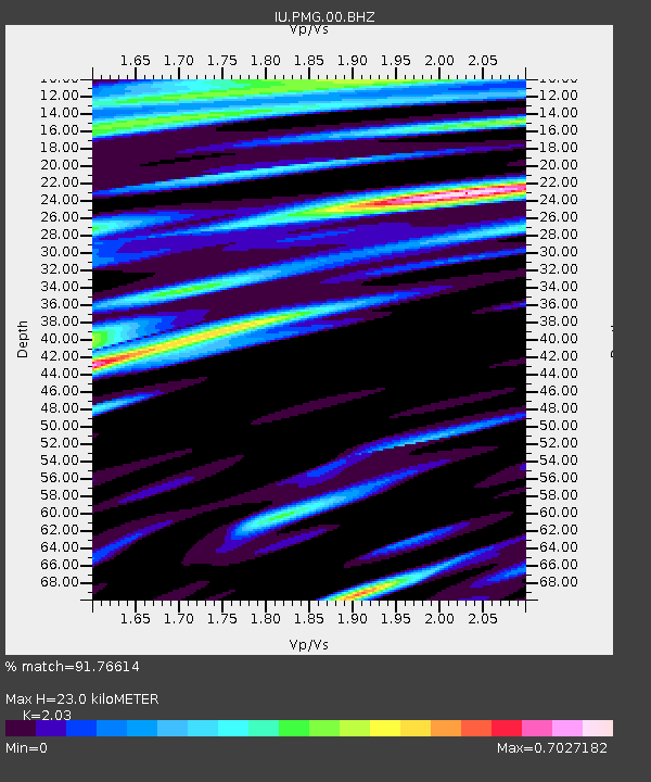
| Estimated Moho Depth: |
23.0 km |
| Estimated Crust Vp/Vs: |
2.03 |
| Assumed Crust Vp: |
6.122 km/s |
| Estimated Crust Vs: |
3.016 km/s |
| Estimated Crust Poisson's Ratio: |
0.34 |
|
| Radial Match: |
91.76614 % |
| Radial Bump: |
400 |
| Transverse Match: |
91.227 % |
| Transverse Bump: |
400 |
| SOD ConfigId: |
29823551 |
| Insert Time: |
2022-12-22 00:56:15.382 +0000 |
| GWidth: |
2.5 |
| Max Bumps: |
400 |
| Tol: |
0.001 |
|

Signal To Noise
| Channel | StoN | STA | LTA |
| IU:PMG:00:BHZ:20221208T00:57:46.969012Z | 56.601746 | 4.4006456E-6 | 7.774753E-8 |
| IU:PMG:00:BH1:20221208T00:57:46.969012Z | 12.024729 | 1.2618758E-6 | 1.04940064E-7 |
| IU:PMG:00:BH2:20221208T00:57:46.969012Z | 22.442617 | 1.8226921E-6 | 8.121567E-8 |
| Arrivals |
| Ps | 4.1 SECOND |
| PpPs | 11 SECOND |
| PsPs/PpSs | 15 SECOND |


