You are here: Home > Network List > IU - Global Seismograph Network (GSN - IRIS/USGS) Stations List
> Station XMAS Kiritimati Island, Republic of Kiribati > Earthquake Result Viewer
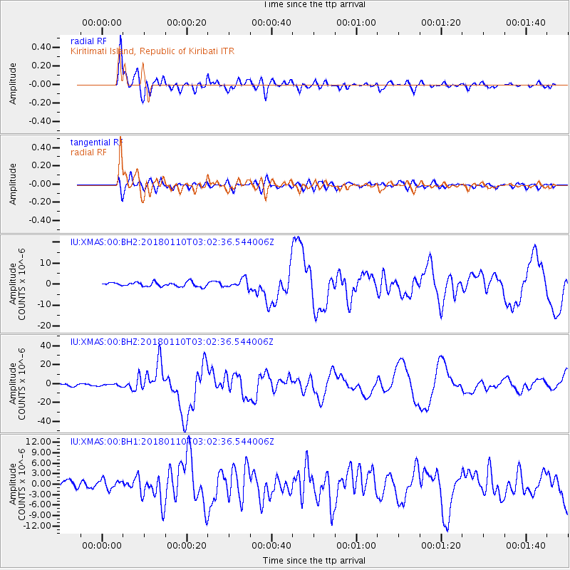
XMAS Kiritimati Island, Republic of Kiribati - Earthquake Result Viewer
*The percent match for this event was below the threshold and hence no stack was calculated.
| Earthquake location: |
North Of Honduras |
| Earthquake latitude/longitude: |
17.5/-83.6 |
| Earthquake time(UTC): |
2018/01/10 (010) 02:51:31 GMT |
| Earthquake Depth: |
33 km |
| Earthquake Magnitude: |
7.8 Mi |
| Earthquake Catalog/Contributor: |
NEIC PDE/pt |
|
| Network: |
IU Global Seismograph Network (GSN - IRIS/USGS) |
| Station: |
XMAS Kiritimati Island, Republic of Kiribati |
| Lat/Lon: |
2.04 N/157.45 W |
| Elevation: |
20 m |
|
| Distance: |
74.0 deg |
| Az: |
267.073 deg |
| Baz: |
72.483 deg |
| Ray Param: |
$rayparam |
*The percent match for this event was below the threshold and hence was not used in the summary stack. |
|
| Radial Match: |
95.74054 % |
| Radial Bump: |
400 |
| Transverse Match: |
79.97417 % |
| Transverse Bump: |
400 |
| SOD ConfigId: |
2973751 |
| Insert Time: |
2018-10-09 05:29:39.206 +0000 |
| GWidth: |
2.5 |
| Max Bumps: |
400 |
| Tol: |
0.001 |
|
Signal To Noise
| Channel | StoN | STA | LTA |
| IU:XMAS:00:BHZ:20180110T03:02:36.544006Z | 1.1669734 | 1.1333686E-6 | 9.712036E-7 |
| IU:XMAS:00:BH1:20180110T03:02:36.544006Z | 1.3263937 | 1.4302263E-6 | 1.0782819E-6 |
| IU:XMAS:00:BH2:20180110T03:02:36.544006Z | 1.2087222 | 1.0850441E-6 | 8.976786E-7 |
| Arrivals |
| Ps | |
| PpPs | |
| PsPs/PpSs | |


