You are here: Home > Network List > TA - USArray Transportable Network (new EarthScope stations) Stations List
> Station T25A Trinidad, CO, USA > Earthquake Result Viewer
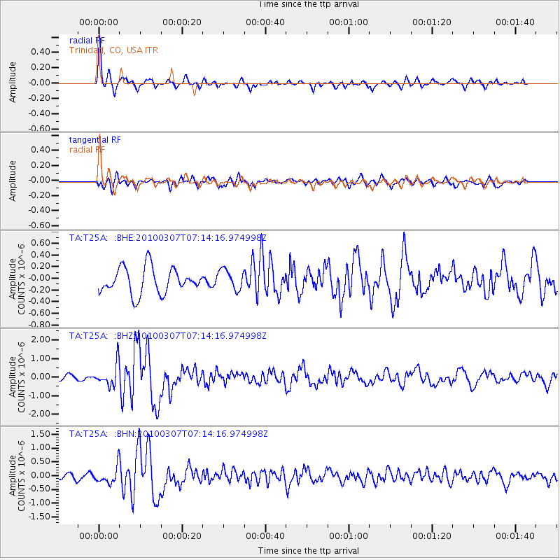
T25A Trinidad, CO, USA - Earthquake Result Viewer
*The percent match for this event was below the threshold and hence no stack was calculated.
| Earthquake location: |
Southern East Pacific Rise |
| Earthquake latitude/longitude: |
-16.2/-115.3 |
| Earthquake time(UTC): |
2010/03/07 (066) 07:05:23 GMT |
| Earthquake Depth: |
10 km |
| Earthquake Magnitude: |
5.8 MB, 5.7 MS, 6.3 MW, 6.2 MW |
| Earthquake Catalog/Contributor: |
WHDF/NEIC |
|
| Network: |
TA USArray Transportable Network (new EarthScope stations) |
| Station: |
T25A Trinidad, CO, USA |
| Lat/Lon: |
37.14 N/104.41 W |
| Elevation: |
2017 m |
|
| Distance: |
54.1 deg |
| Az: |
10.741 deg |
| Baz: |
192.945 deg |
| Ray Param: |
$rayparam |
*The percent match for this event was below the threshold and hence was not used in the summary stack. |
|
| Radial Match: |
77.4523 % |
| Radial Bump: |
330 |
| Transverse Match: |
58.044136 % |
| Transverse Bump: |
400 |
| SOD ConfigId: |
299721 |
| Insert Time: |
2010-04-26 17:53:01.383 +0000 |
| GWidth: |
2.5 |
| Max Bumps: |
400 |
| Tol: |
0.001 |
|
Signal To Noise
| Channel | StoN | STA | LTA |
| TA:T25A: :BHZ:20100307T07:14:16.974998Z | 3.9150572 | 6.1087803E-7 | 1.5603297E-7 |
| TA:T25A: :BHN:20100307T07:14:16.974998Z | 1.8309425 | 3.1367108E-7 | 1.7131673E-7 |
| TA:T25A: :BHE:20100307T07:14:16.974998Z | 0.8011008 | 1.7649316E-7 | 2.2031331E-7 |
| Arrivals |
| Ps | |
| PpPs | |
| PsPs/PpSs | |


