You are here: Home > Network List > TA - USArray Transportable Network (new EarthScope stations) Stations List
> Station F19A Roth Fram, Molt, MT, USA > Earthquake Result Viewer
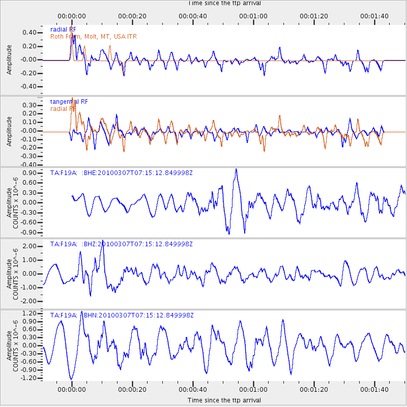
F19A Roth Fram, Molt, MT, USA - Earthquake Result Viewer
*The percent match for this event was below the threshold and hence no stack was calculated.
| Earthquake location: |
Southern East Pacific Rise |
| Earthquake latitude/longitude: |
-16.2/-115.3 |
| Earthquake time(UTC): |
2010/03/07 (066) 07:05:23 GMT |
| Earthquake Depth: |
10 km |
| Earthquake Magnitude: |
5.8 MB, 5.7 MS, 6.3 MW, 6.2 MW |
| Earthquake Catalog/Contributor: |
WHDF/NEIC |
|
| Network: |
TA USArray Transportable Network (new EarthScope stations) |
| Station: |
F19A Roth Fram, Molt, MT, USA |
| Lat/Lon: |
45.85 N/108.94 W |
| Elevation: |
1243 m |
|
| Distance: |
62.1 deg |
| Az: |
5.022 deg |
| Baz: |
186.91 deg |
| Ray Param: |
$rayparam |
*The percent match for this event was below the threshold and hence was not used in the summary stack. |
|
| Radial Match: |
69.34168 % |
| Radial Bump: |
327 |
| Transverse Match: |
59.15584 % |
| Transverse Bump: |
303 |
| SOD ConfigId: |
299721 |
| Insert Time: |
2010-04-26 17:55:08.301 +0000 |
| GWidth: |
2.5 |
| Max Bumps: |
400 |
| Tol: |
0.001 |
|
Signal To Noise
| Channel | StoN | STA | LTA |
| TA:F19A: :BHZ:20100307T07:15:12.849998Z | 1.8348304 | 6.3076754E-7 | 3.437743E-7 |
| TA:F19A: :BHN:20100307T07:15:12.849998Z | 1.7490374 | 8.655912E-7 | 4.9489574E-7 |
| TA:F19A: :BHE:20100307T07:15:12.849998Z | 1.02012 | 1.7554395E-7 | 1.7208167E-7 |
| Arrivals |
| Ps | |
| PpPs | |
| PsPs/PpSs | |


