You are here: Home > Network List > US - United States National Seismic Network Stations List
> Station BOZ Bozeman, Montana, USA > Earthquake Result Viewer
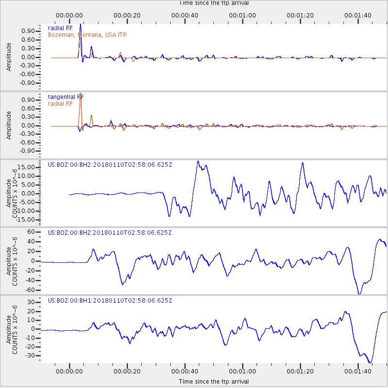
BOZ Bozeman, Montana, USA - Earthquake Result Viewer
*The percent match for this event was below the threshold and hence no stack was calculated.
| Earthquake location: |
North Of Honduras |
| Earthquake latitude/longitude: |
17.5/-83.6 |
| Earthquake time(UTC): |
2018/01/10 (010) 02:51:31 GMT |
| Earthquake Depth: |
33 km |
| Earthquake Magnitude: |
7.8 Mi |
| Earthquake Catalog/Contributor: |
NEIC PDE/pt |
|
| Network: |
US United States National Seismic Network |
| Station: |
BOZ Bozeman, Montana, USA |
| Lat/Lon: |
45.65 N/111.63 W |
| Elevation: |
1589 m |
|
| Distance: |
36.5 deg |
| Az: |
326.307 deg |
| Baz: |
131.004 deg |
| Ray Param: |
$rayparam |
*The percent match for this event was below the threshold and hence was not used in the summary stack. |
|
| Radial Match: |
90.74349 % |
| Radial Bump: |
291 |
| Transverse Match: |
79.51639 % |
| Transverse Bump: |
400 |
| SOD ConfigId: |
2973751 |
| Insert Time: |
2018-10-09 05:30:26.016 +0000 |
| GWidth: |
2.5 |
| Max Bumps: |
400 |
| Tol: |
0.001 |
|
Signal To Noise
| Channel | StoN | STA | LTA |
| US:BOZ:00:BHZ:20180110T02:58:06.625Z | 2.0754828 | 9.607197E-7 | 4.6288977E-7 |
| US:BOZ:00:BH1:20180110T02:58:06.625Z | 2.130452 | 6.073007E-7 | 2.8505724E-7 |
| US:BOZ:00:BH2:20180110T02:58:06.625Z | 1.8860394 | 5.4580414E-7 | 2.8939172E-7 |
| Arrivals |
| Ps | |
| PpPs | |
| PsPs/PpSs | |


