You are here: Home > Network List > US - United States National Seismic Network Stations List
> Station DGMT Dagmar, Montana, USA > Earthquake Result Viewer
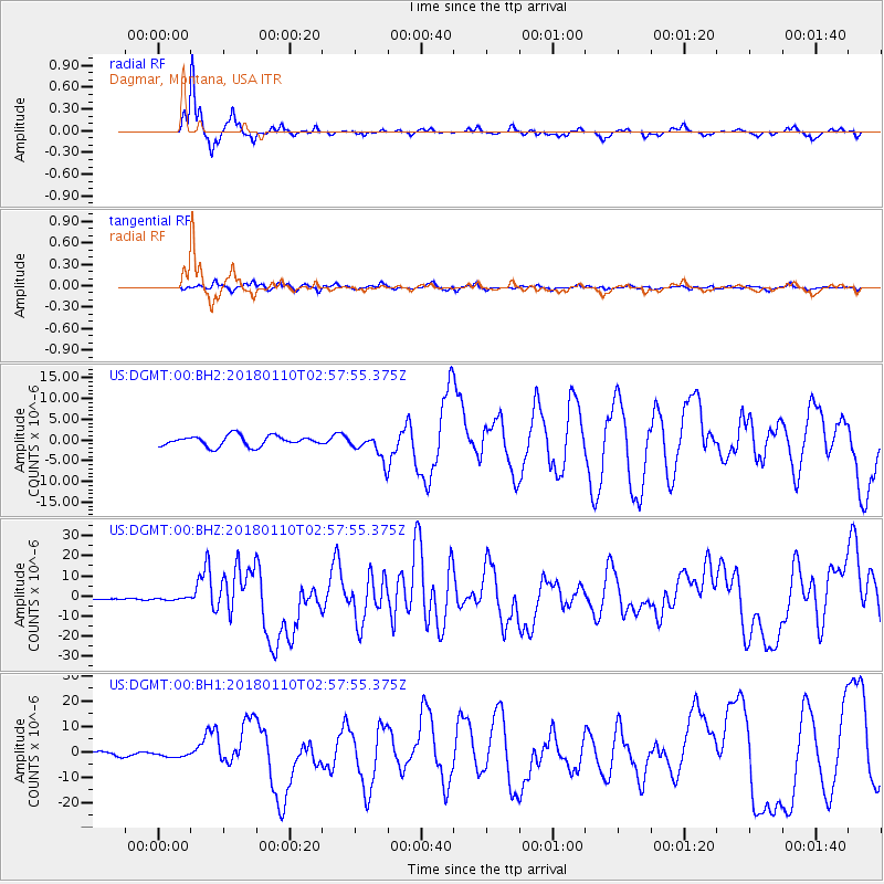
DGMT Dagmar, Montana, USA - Earthquake Result Viewer
*The percent match for this event was below the threshold and hence no stack was calculated.
| Earthquake location: |
North Of Honduras |
| Earthquake latitude/longitude: |
17.5/-83.6 |
| Earthquake time(UTC): |
2018/01/10 (010) 02:51:31 GMT |
| Earthquake Depth: |
33 km |
| Earthquake Magnitude: |
7.8 Mi |
| Earthquake Catalog/Contributor: |
NEIC PDE/pt |
|
| Network: |
US United States National Seismic Network |
| Station: |
DGMT Dagmar, Montana, USA |
| Lat/Lon: |
48.47 N/104.20 W |
| Elevation: |
0.0 m |
|
| Distance: |
35.2 deg |
| Az: |
335.971 deg |
| Baz: |
144.276 deg |
| Ray Param: |
$rayparam |
*The percent match for this event was below the threshold and hence was not used in the summary stack. |
|
| Radial Match: |
95.07998 % |
| Radial Bump: |
210 |
| Transverse Match: |
73.3572 % |
| Transverse Bump: |
400 |
| SOD ConfigId: |
2973751 |
| Insert Time: |
2018-10-09 05:30:28.738 +0000 |
| GWidth: |
2.5 |
| Max Bumps: |
400 |
| Tol: |
0.001 |
|
Signal To Noise
| Channel | StoN | STA | LTA |
| US:DGMT:00:BHZ:20180110T02:57:55.375Z | 1.114847 | 5.997213E-7 | 5.379405E-7 |
| US:DGMT:00:BH1:20180110T02:57:55.375Z | 1.0642301 | 1.0438036E-6 | 9.808065E-7 |
| US:DGMT:00:BH2:20180110T02:57:55.375Z | 1.0222197 | 1.3871252E-6 | 1.3569736E-6 |
| Arrivals |
| Ps | |
| PpPs | |
| PsPs/PpSs | |


