You are here: Home > Network List > TA - USArray Transportable Network (new EarthScope stations) Stations List
> Station G22A Birney, MT, USA > Earthquake Result Viewer
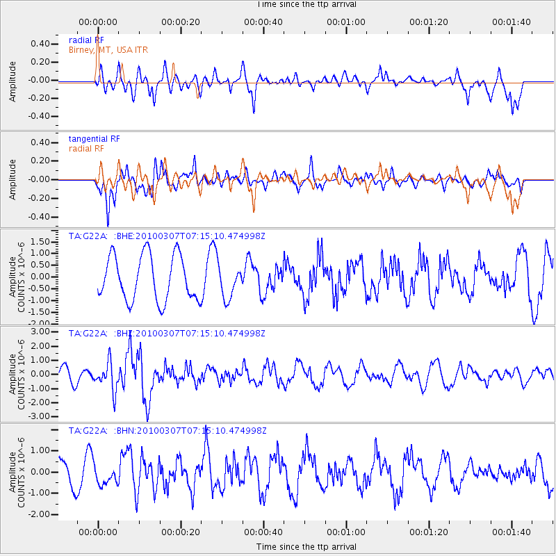
G22A Birney, MT, USA - Earthquake Result Viewer
*The percent match for this event was below the threshold and hence no stack was calculated.
| Earthquake location: |
Southern East Pacific Rise |
| Earthquake latitude/longitude: |
-16.2/-115.3 |
| Earthquake time(UTC): |
2010/03/07 (066) 07:05:23 GMT |
| Earthquake Depth: |
10 km |
| Earthquake Magnitude: |
5.8 MB, 5.7 MS, 6.3 MW, 6.2 MW |
| Earthquake Catalog/Contributor: |
WHDF/NEIC |
|
| Network: |
TA USArray Transportable Network (new EarthScope stations) |
| Station: |
G22A Birney, MT, USA |
| Lat/Lon: |
45.22 N/106.29 W |
| Elevation: |
1203 m |
|
| Distance: |
61.7 deg |
| Az: |
7.217 deg |
| Baz: |
189.831 deg |
| Ray Param: |
$rayparam |
*The percent match for this event was below the threshold and hence was not used in the summary stack. |
|
| Radial Match: |
54.442593 % |
| Radial Bump: |
355 |
| Transverse Match: |
70.63281 % |
| Transverse Bump: |
370 |
| SOD ConfigId: |
299721 |
| Insert Time: |
2010-04-26 17:58:54.970 +0000 |
| GWidth: |
2.5 |
| Max Bumps: |
400 |
| Tol: |
0.001 |
|
Signal To Noise
| Channel | StoN | STA | LTA |
| TA:G22A: :BHZ:20100307T07:15:10.474998Z | 2.096265 | 1.0175052E-6 | 4.8538953E-7 |
| TA:G22A: :BHN:20100307T07:15:10.474998Z | 0.63339245 | 4.2443193E-7 | 6.7009313E-7 |
| TA:G22A: :BHE:20100307T07:15:10.474998Z | 0.69990826 | 6.6734555E-7 | 9.534757E-7 |
| Arrivals |
| Ps | |
| PpPs | |
| PsPs/PpSs | |


