You are here: Home > Network List > TA - USArray Transportable Network (new EarthScope stations) Stations List
> Station T28A Walsh, CO, USA > Earthquake Result Viewer
T28A Walsh, CO, USA - Earthquake Result Viewer
| Earthquake location: |
Southern East Pacific Rise |
| Earthquake latitude/longitude: |
-16.2/-115.3 |
| Earthquake time(UTC): |
2010/03/07 (066) 07:05:23 GMT |
| Earthquake Depth: |
10 km |
| Earthquake Magnitude: |
5.8 MB, 5.7 MS, 6.3 MW, 6.2 MW |
| Earthquake Catalog/Contributor: |
WHDF/NEIC |
|
| Network: |
TA USArray Transportable Network (new EarthScope stations) |
| Station: |
T28A Walsh, CO, USA |
| Lat/Lon: |
37.12 N/102.11 W |
| Elevation: |
1148 m |
|
| Distance: |
54.5 deg |
| Az: |
12.937 deg |
| Baz: |
195.608 deg |
| Ray Param: |
0.06540161 |
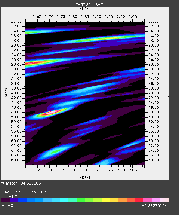
| Estimated Moho Depth: |
47.75 km |
| Estimated Crust Vp/Vs: |
1.71 |
| Assumed Crust Vp: |
6.306 km/s |
| Estimated Crust Vs: |
3.688 km/s |
| Estimated Crust Poisson's Ratio: |
0.24 |
|
| Radial Match: |
84.613106 % |
| Radial Bump: |
400 |
| Transverse Match: |
51.997696 % |
| Transverse Bump: |
396 |
| SOD ConfigId: |
299721 |
| Insert Time: |
2010-04-26 18:00:16.518 +0000 |
| GWidth: |
2.5 |
| Max Bumps: |
400 |
| Tol: |
0.001 |
|
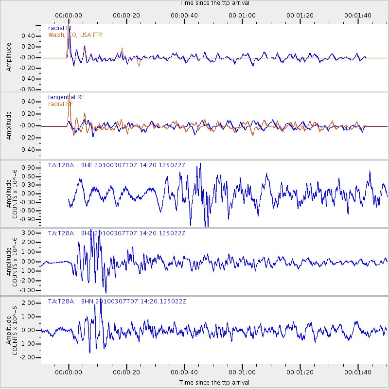
Signal To Noise
| Channel | StoN | STA | LTA |
| TA:T28A: :BHZ:20100307T07:14:20.125022Z | 5.741075 | 9.5014644E-7 | 1.6549974E-7 |
| TA:T28A: :BHN:20100307T07:14:20.125022Z | 2.315823 | 4.0752715E-7 | 1.7597509E-7 |
| TA:T28A: :BHE:20100307T07:14:20.125022Z | 1.5822916 | 3.483265E-7 | 2.2014052E-7 |
| Arrivals |
| Ps | 5.7 SECOND |
| PpPs | 19 SECOND |
| PsPs/PpSs | 25 SECOND |


