You are here: Home > Network List > TA - USArray Transportable Network (new EarthScope stations) Stations List
> Station X29A Tulia, tX, USA > Earthquake Result Viewer
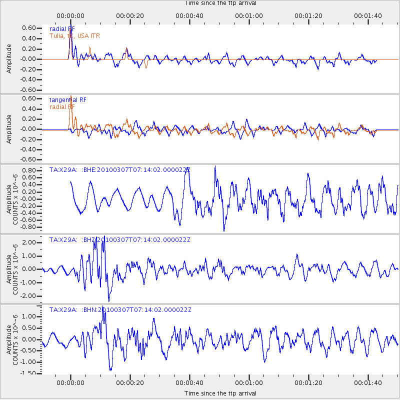
X29A Tulia, tX, USA - Earthquake Result Viewer
*The percent match for this event was below the threshold and hence no stack was calculated.
| Earthquake location: |
Southern East Pacific Rise |
| Earthquake latitude/longitude: |
-16.2/-115.3 |
| Earthquake time(UTC): |
2010/03/07 (066) 07:05:23 GMT |
| Earthquake Depth: |
10 km |
| Earthquake Magnitude: |
5.8 MB, 5.7 MS, 6.3 MW, 6.2 MW |
| Earthquake Catalog/Contributor: |
WHDF/NEIC |
|
| Network: |
TA USArray Transportable Network (new EarthScope stations) |
| Station: |
X29A Tulia, tX, USA |
| Lat/Lon: |
34.45 N/101.70 W |
| Elevation: |
1039 m |
|
| Distance: |
52.0 deg |
| Az: |
14.265 deg |
| Baz: |
196.643 deg |
| Ray Param: |
$rayparam |
*The percent match for this event was below the threshold and hence was not used in the summary stack. |
|
| Radial Match: |
72.214714 % |
| Radial Bump: |
400 |
| Transverse Match: |
45.42344 % |
| Transverse Bump: |
343 |
| SOD ConfigId: |
299721 |
| Insert Time: |
2010-04-26 18:00:55.129 +0000 |
| GWidth: |
2.5 |
| Max Bumps: |
400 |
| Tol: |
0.001 |
|
Signal To Noise
| Channel | StoN | STA | LTA |
| TA:X29A: :BHZ:20100307T07:14:02.000022Z | 3.2628021 | 5.7725543E-7 | 1.7692014E-7 |
| TA:X29A: :BHN:20100307T07:14:02.000022Z | 0.9508132 | 2.1864618E-7 | 2.2995704E-7 |
| TA:X29A: :BHE:20100307T07:14:02.000022Z | 1.0774204 | 2.5399655E-7 | 2.3574509E-7 |
| Arrivals |
| Ps | |
| PpPs | |
| PsPs/PpSs | |


