You are here: Home > Network List > TA - USArray Transportable Network (new EarthScope stations) Stations List
> Station Z28A Tucker Farm, Meadow, TX, USA > Earthquake Result Viewer
Z28A Tucker Farm, Meadow, TX, USA - Earthquake Result Viewer
| Earthquake location: |
Southern East Pacific Rise |
| Earthquake latitude/longitude: |
-16.2/-115.3 |
| Earthquake time(UTC): |
2010/03/07 (066) 07:05:23 GMT |
| Earthquake Depth: |
10 km |
| Earthquake Magnitude: |
5.8 MB, 5.7 MS, 6.3 MW, 6.2 MW |
| Earthquake Catalog/Contributor: |
WHDF/NEIC |
|
| Network: |
TA USArray Transportable Network (new EarthScope stations) |
| Station: |
Z28A Tucker Farm, Meadow, TX, USA |
| Lat/Lon: |
33.29 N/102.39 W |
| Elevation: |
1045 m |
|
| Distance: |
50.8 deg |
| Az: |
13.98 deg |
| Baz: |
196.085 deg |
| Ray Param: |
0.06783061 |
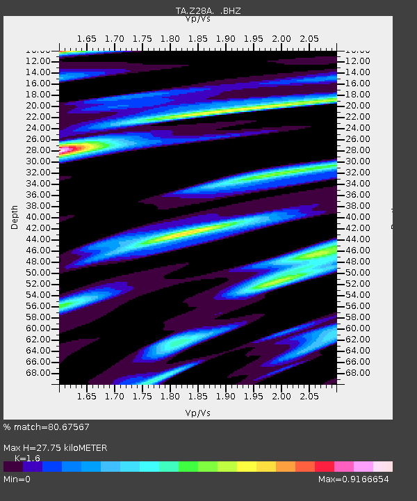
| Estimated Moho Depth: |
27.75 km |
| Estimated Crust Vp/Vs: |
1.60 |
| Assumed Crust Vp: |
6.129 km/s |
| Estimated Crust Vs: |
3.831 km/s |
| Estimated Crust Poisson's Ratio: |
0.18 |
|
| Radial Match: |
80.67567 % |
| Radial Bump: |
323 |
| Transverse Match: |
70.980934 % |
| Transverse Bump: |
376 |
| SOD ConfigId: |
299721 |
| Insert Time: |
2010-04-26 18:01:03.631 +0000 |
| GWidth: |
2.5 |
| Max Bumps: |
400 |
| Tol: |
0.001 |
|
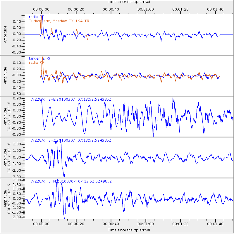
Signal To Noise
| Channel | StoN | STA | LTA |
| TA:Z28A: :BHZ:20100307T07:13:52.524985Z | 2.2406955 | 6.524816E-7 | 2.9119602E-7 |
| TA:Z28A: :BHN:20100307T07:13:52.524985Z | 1.1065379 | 2.8704235E-7 | 2.594058E-7 |
| TA:Z28A: :BHE:20100307T07:13:52.524985Z | 0.59735936 | 2.0873308E-7 | 3.494263E-7 |
| Arrivals |
| Ps | 2.9 SECOND |
| PpPs | 11 SECOND |
| PsPs/PpSs | 14 SECOND |


