You are here: Home > Network List > TA - USArray Transportable Network (new EarthScope stations) Stations List
> Station 431A Sonora, TX, USA > Earthquake Result Viewer
431A Sonora, TX, USA - Earthquake Result Viewer
| Earthquake location: |
Southern East Pacific Rise |
| Earthquake latitude/longitude: |
-16.2/-115.3 |
| Earthquake time(UTC): |
2010/03/07 (066) 07:05:23 GMT |
| Earthquake Depth: |
10 km |
| Earthquake Magnitude: |
5.8 MB, 5.7 MS, 6.3 MW, 6.2 MW |
| Earthquake Catalog/Contributor: |
WHDF/NEIC |
|
| Network: |
TA USArray Transportable Network (new EarthScope stations) |
| Station: |
431A Sonora, TX, USA |
| Lat/Lon: |
30.68 N/100.61 W |
| Elevation: |
700 m |
|
| Distance: |
48.7 deg |
| Az: |
16.892 deg |
| Baz: |
198.904 deg |
| Ray Param: |
0.06915423 |
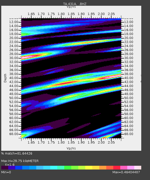
| Estimated Moho Depth: |
29.75 km |
| Estimated Crust Vp/Vs: |
1.60 |
| Assumed Crust Vp: |
6.38 km/s |
| Estimated Crust Vs: |
3.988 km/s |
| Estimated Crust Poisson's Ratio: |
0.18 |
|
| Radial Match: |
81.64426 % |
| Radial Bump: |
400 |
| Transverse Match: |
63.21079 % |
| Transverse Bump: |
400 |
| SOD ConfigId: |
299721 |
| Insert Time: |
2010-04-26 18:02:07.445 +0000 |
| GWidth: |
2.5 |
| Max Bumps: |
400 |
| Tol: |
0.001 |
|
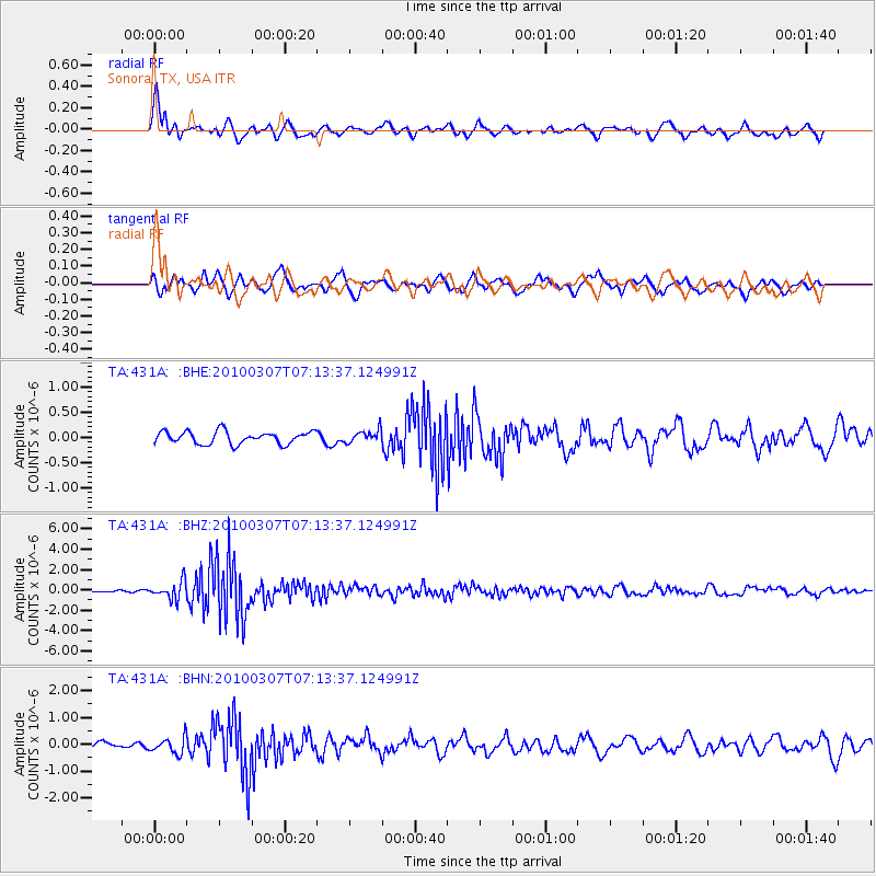
Signal To Noise
| Channel | StoN | STA | LTA |
| TA:431A: :BHZ:20100307T07:13:37.124991Z | 4.585826 | 8.586496E-7 | 1.872399E-7 |
| TA:431A: :BHN:20100307T07:13:37.124991Z | 1.9816654 | 2.9505455E-7 | 1.4889221E-7 |
| TA:431A: :BHE:20100307T07:13:37.124991Z | 0.99757856 | 1.2382043E-7 | 1.2412097E-7 |
| Arrivals |
| Ps | 3.0 SECOND |
| PpPs | 11 SECOND |
| PsPs/PpSs | 14 SECOND |


