You are here: Home > Network List > TA - USArray Transportable Network (new EarthScope stations) Stations List
> Station 530A J-C Ranch, Comstock, TX, USA > Earthquake Result Viewer
530A J-C Ranch, Comstock, TX, USA - Earthquake Result Viewer
| Earthquake location: |
Southern East Pacific Rise |
| Earthquake latitude/longitude: |
-16.2/-115.3 |
| Earthquake time(UTC): |
2010/03/07 (066) 07:05:23 GMT |
| Earthquake Depth: |
10 km |
| Earthquake Magnitude: |
5.8 MB, 5.7 MS, 6.3 MW, 6.2 MW |
| Earthquake Catalog/Contributor: |
WHDF/NEIC |
|
| Network: |
TA USArray Transportable Network (new EarthScope stations) |
| Station: |
530A J-C Ranch, Comstock, TX, USA |
| Lat/Lon: |
30.15 N/101.34 W |
| Elevation: |
636 m |
|
| Distance: |
48.0 deg |
| Az: |
16.318 deg |
| Baz: |
198.155 deg |
| Ray Param: |
0.069608465 |
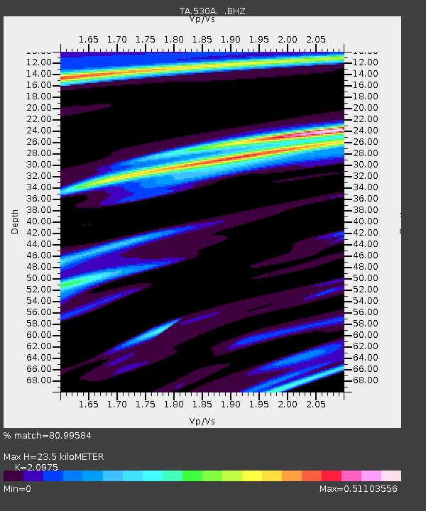
| Estimated Moho Depth: |
23.5 km |
| Estimated Crust Vp/Vs: |
2.10 |
| Assumed Crust Vp: |
6.38 km/s |
| Estimated Crust Vs: |
3.042 km/s |
| Estimated Crust Poisson's Ratio: |
0.35 |
|
| Radial Match: |
80.99584 % |
| Radial Bump: |
267 |
| Transverse Match: |
52.307926 % |
| Transverse Bump: |
395 |
| SOD ConfigId: |
299721 |
| Insert Time: |
2010-04-26 18:02:33.830 +0000 |
| GWidth: |
2.5 |
| Max Bumps: |
400 |
| Tol: |
0.001 |
|

Signal To Noise
| Channel | StoN | STA | LTA |
| TA:530A: :BHZ:20100307T07:13:31.700004Z | 2.3165662 | 4.5008562E-7 | 1.9428998E-7 |
| TA:530A: :BHN:20100307T07:13:31.700004Z | 1.1148782 | 2.3139675E-7 | 2.075534E-7 |
| TA:530A: :BHE:20100307T07:13:31.700004Z | 2.3073528 | 1.9531471E-7 | 8.464883E-8 |
| Arrivals |
| Ps | 4.3 SECOND |
| PpPs | 11 SECOND |
| PsPs/PpSs | 15 SECOND |


