You are here: Home > Network List > TA - USArray Transportable Network (new EarthScope stations) Stations List
> Station S30A Montezuma, KS, USA > Earthquake Result Viewer
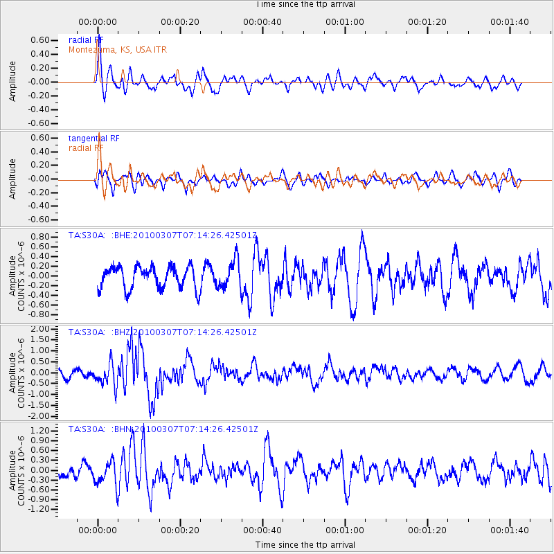
S30A Montezuma, KS, USA - Earthquake Result Viewer
*The percent match for this event was below the threshold and hence no stack was calculated.
| Earthquake location: |
Southern East Pacific Rise |
| Earthquake latitude/longitude: |
-16.2/-115.3 |
| Earthquake time(UTC): |
2010/03/07 (066) 07:05:23 GMT |
| Earthquake Depth: |
10 km |
| Earthquake Magnitude: |
5.8 MB, 5.7 MS, 6.3 MW, 6.2 MW |
| Earthquake Catalog/Contributor: |
WHDF/NEIC |
|
| Network: |
TA USArray Transportable Network (new EarthScope stations) |
| Station: |
S30A Montezuma, KS, USA |
| Lat/Lon: |
37.64 N/100.46 W |
| Elevation: |
853 m |
|
| Distance: |
55.4 deg |
| Az: |
14.297 deg |
| Baz: |
197.386 deg |
| Ray Param: |
$rayparam |
*The percent match for this event was below the threshold and hence was not used in the summary stack. |
|
| Radial Match: |
67.909615 % |
| Radial Bump: |
400 |
| Transverse Match: |
55.328552 % |
| Transverse Bump: |
400 |
| SOD ConfigId: |
299721 |
| Insert Time: |
2010-04-26 18:05:39.272 +0000 |
| GWidth: |
2.5 |
| Max Bumps: |
400 |
| Tol: |
0.001 |
|
Signal To Noise
| Channel | StoN | STA | LTA |
| TA:S30A: :BHZ:20100307T07:14:26.42501Z | 3.2905297 | 5.1847434E-7 | 1.5756561E-7 |
| TA:S30A: :BHN:20100307T07:14:26.42501Z | 1.6541771 | 3.7512677E-7 | 2.2677546E-7 |
| TA:S30A: :BHE:20100307T07:14:26.42501Z | 1.3271155 | 3.0034474E-7 | 2.2631393E-7 |
| Arrivals |
| Ps | |
| PpPs | |
| PsPs/PpSs | |


