You are here: Home > Network List > TA - USArray Transportable Network (new EarthScope stations) Stations List
> Station R30A Dighton, KS, USA > Earthquake Result Viewer
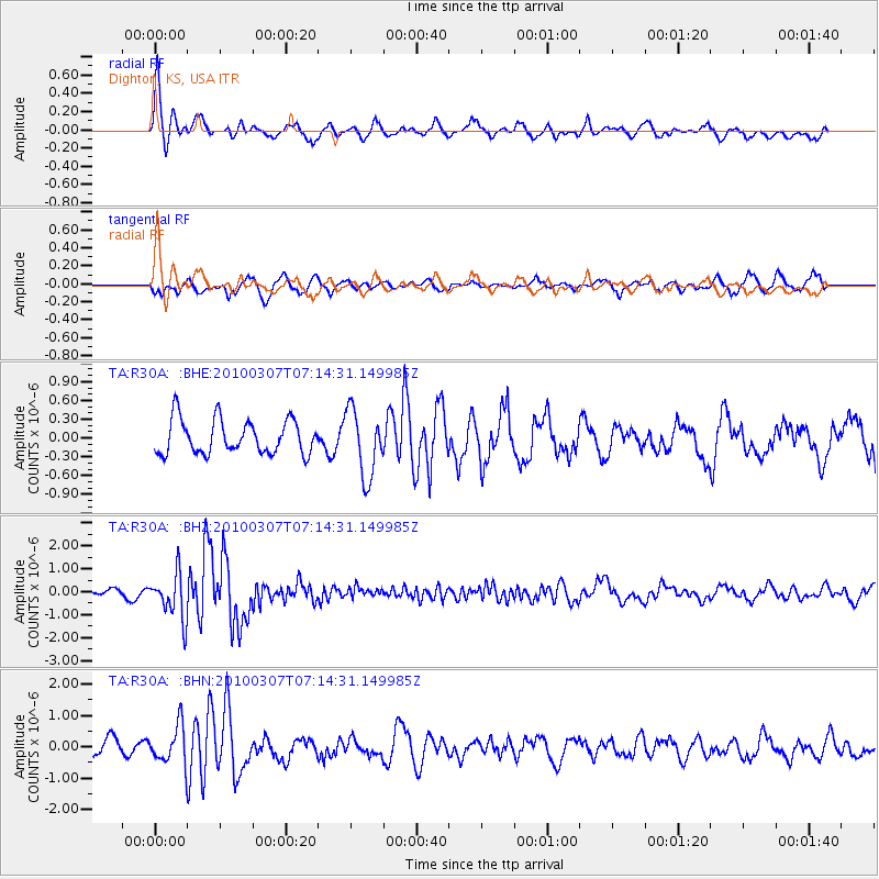
R30A Dighton, KS, USA - Earthquake Result Viewer
*The percent match for this event was below the threshold and hence no stack was calculated.
| Earthquake location: |
Southern East Pacific Rise |
| Earthquake latitude/longitude: |
-16.2/-115.3 |
| Earthquake time(UTC): |
2010/03/07 (066) 07:05:23 GMT |
| Earthquake Depth: |
10 km |
| Earthquake Magnitude: |
5.8 MB, 5.7 MS, 6.3 MW, 6.2 MW |
| Earthquake Catalog/Contributor: |
WHDF/NEIC |
|
| Network: |
TA USArray Transportable Network (new EarthScope stations) |
| Station: |
R30A Dighton, KS, USA |
| Lat/Lon: |
38.28 N/100.28 W |
| Elevation: |
776 m |
|
| Distance: |
56.0 deg |
| Az: |
14.234 deg |
| Baz: |
197.466 deg |
| Ray Param: |
$rayparam |
*The percent match for this event was below the threshold and hence was not used in the summary stack. |
|
| Radial Match: |
77.235565 % |
| Radial Bump: |
377 |
| Transverse Match: |
55.449963 % |
| Transverse Bump: |
390 |
| SOD ConfigId: |
299721 |
| Insert Time: |
2010-04-26 18:05:40.160 +0000 |
| GWidth: |
2.5 |
| Max Bumps: |
400 |
| Tol: |
0.001 |
|
Signal To Noise
| Channel | StoN | STA | LTA |
| TA:R30A: :BHZ:20100307T07:14:31.149985Z | 9.310068 | 9.894155E-7 | 1.06273724E-7 |
| TA:R30A: :BHN:20100307T07:14:31.149985Z | 2.1224942 | 6.058223E-7 | 2.8542942E-7 |
| TA:R30A: :BHE:20100307T07:14:31.149985Z | 1.9689064 | 5.336597E-7 | 2.7104372E-7 |
| Arrivals |
| Ps | |
| PpPs | |
| PsPs/PpSs | |


