You are here: Home > Network List > TA - USArray Transportable Network (new EarthScope stations) Stations List
> Station Q29A Oakley, KS, USA > Earthquake Result Viewer
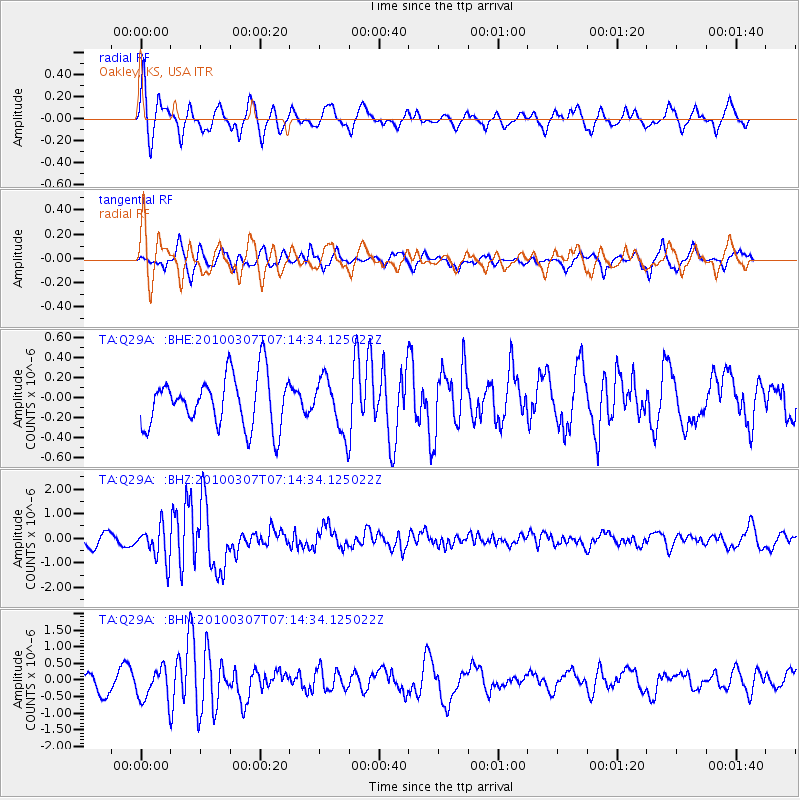
Q29A Oakley, KS, USA - Earthquake Result Viewer
*The percent match for this event was below the threshold and hence no stack was calculated.
| Earthquake location: |
Southern East Pacific Rise |
| Earthquake latitude/longitude: |
-16.2/-115.3 |
| Earthquake time(UTC): |
2010/03/07 (066) 07:05:23 GMT |
| Earthquake Depth: |
10 km |
| Earthquake Magnitude: |
5.8 MB, 5.7 MS, 6.3 MW, 6.2 MW |
| Earthquake Catalog/Contributor: |
WHDF/NEIC |
|
| Network: |
TA USArray Transportable Network (new EarthScope stations) |
| Station: |
Q29A Oakley, KS, USA |
| Lat/Lon: |
38.89 N/100.98 W |
| Elevation: |
895 m |
|
| Distance: |
56.5 deg |
| Az: |
13.389 deg |
| Baz: |
196.56 deg |
| Ray Param: |
$rayparam |
*The percent match for this event was below the threshold and hence was not used in the summary stack. |
|
| Radial Match: |
71.451225 % |
| Radial Bump: |
378 |
| Transverse Match: |
57.93073 % |
| Transverse Bump: |
400 |
| SOD ConfigId: |
299721 |
| Insert Time: |
2010-04-26 18:06:22.389 +0000 |
| GWidth: |
2.5 |
| Max Bumps: |
400 |
| Tol: |
0.001 |
|
Signal To Noise
| Channel | StoN | STA | LTA |
| TA:Q29A: :BHZ:20100307T07:14:34.125022Z | 3.8177266 | 7.025663E-7 | 1.8402739E-7 |
| TA:Q29A: :BHN:20100307T07:14:34.125022Z | 2.053167 | 4.91313E-7 | 2.392952E-7 |
| TA:Q29A: :BHE:20100307T07:14:34.125022Z | 1.0552744 | 2.667573E-7 | 2.5278476E-7 |
| Arrivals |
| Ps | |
| PpPs | |
| PsPs/PpSs | |


