You are here: Home > Network List > TA - USArray Transportable Network (new EarthScope stations) Stations List
> Station A26A Wade Farm, Kenmare, ND, USA > Earthquake Result Viewer
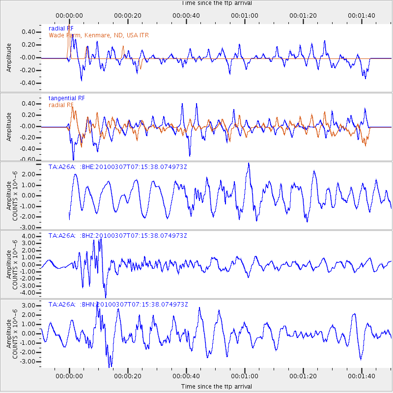
A26A Wade Farm, Kenmare, ND, USA - Earthquake Result Viewer
*The percent match for this event was below the threshold and hence no stack was calculated.
| Earthquake location: |
Southern East Pacific Rise |
| Earthquake latitude/longitude: |
-16.2/-115.3 |
| Earthquake time(UTC): |
2010/03/07 (066) 07:05:23 GMT |
| Earthquake Depth: |
10 km |
| Earthquake Magnitude: |
5.8 MB, 5.7 MS, 6.3 MW, 6.2 MW |
| Earthquake Catalog/Contributor: |
WHDF/NEIC |
|
| Network: |
TA USArray Transportable Network (new EarthScope stations) |
| Station: |
A26A Wade Farm, Kenmare, ND, USA |
| Lat/Lon: |
48.90 N/102.04 W |
| Elevation: |
570 m |
|
| Distance: |
65.9 deg |
| Az: |
9.543 deg |
| Baz: |
193.965 deg |
| Ray Param: |
$rayparam |
*The percent match for this event was below the threshold and hence was not used in the summary stack. |
|
| Radial Match: |
58.2506 % |
| Radial Bump: |
384 |
| Transverse Match: |
62.09144 % |
| Transverse Bump: |
366 |
| SOD ConfigId: |
299721 |
| Insert Time: |
2010-04-26 18:10:20.972 +0000 |
| GWidth: |
2.5 |
| Max Bumps: |
400 |
| Tol: |
0.001 |
|
Signal To Noise
| Channel | StoN | STA | LTA |
| TA:A26A: :BHZ:20100307T07:15:38.074973Z | 2.762264 | 1.0614865E-6 | 3.8428135E-7 |
| TA:A26A: :BHN:20100307T07:15:38.074973Z | 0.8701724 | 7.7212803E-7 | 8.8732764E-7 |
| TA:A26A: :BHE:20100307T07:15:38.074973Z | 1.2102687 | 1.2214718E-6 | 1.0092566E-6 |
| Arrivals |
| Ps | |
| PpPs | |
| PsPs/PpSs | |


