You are here: Home > Network List > TA - USArray Transportable Network (new EarthScope stations) Stations List
> Station X33A Lawton, OK, USA > Earthquake Result Viewer
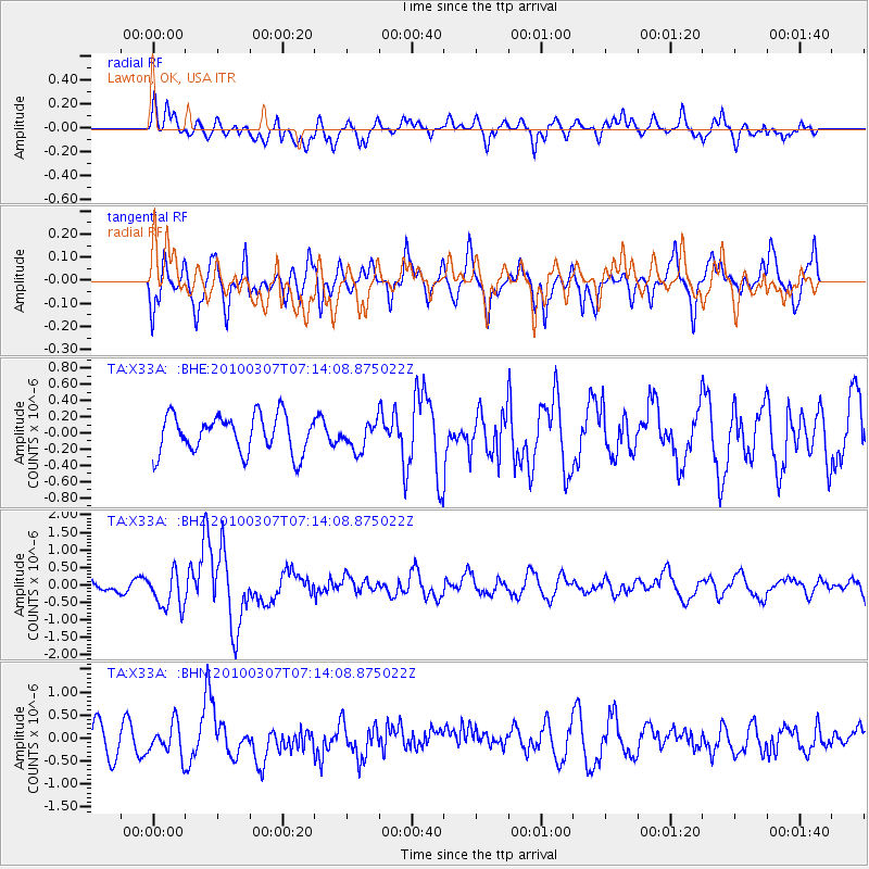
X33A Lawton, OK, USA - Earthquake Result Viewer
*The percent match for this event was below the threshold and hence no stack was calculated.
| Earthquake location: |
Southern East Pacific Rise |
| Earthquake latitude/longitude: |
-16.2/-115.3 |
| Earthquake time(UTC): |
2010/03/07 (066) 07:05:23 GMT |
| Earthquake Depth: |
10 km |
| Earthquake Magnitude: |
5.8 MB, 5.7 MS, 6.3 MW, 6.2 MW |
| Earthquake Catalog/Contributor: |
WHDF/NEIC |
|
| Network: |
TA USArray Transportable Network (new EarthScope stations) |
| Station: |
X33A Lawton, OK, USA |
| Lat/Lon: |
34.54 N/98.50 W |
| Elevation: |
346 m |
|
| Distance: |
53.0 deg |
| Az: |
17.386 deg |
| Baz: |
200.347 deg |
| Ray Param: |
$rayparam |
*The percent match for this event was below the threshold and hence was not used in the summary stack. |
|
| Radial Match: |
59.04752 % |
| Radial Bump: |
400 |
| Transverse Match: |
57.725796 % |
| Transverse Bump: |
400 |
| SOD ConfigId: |
299721 |
| Insert Time: |
2010-04-26 18:13:39.521 +0000 |
| GWidth: |
2.5 |
| Max Bumps: |
400 |
| Tol: |
0.001 |
|
Signal To Noise
| Channel | StoN | STA | LTA |
| TA:X33A: :BHZ:20100307T07:14:08.875022Z | 2.5669677 | 5.202359E-7 | 2.0266553E-7 |
| TA:X33A: :BHN:20100307T07:14:08.875022Z | 1.2112637 | 3.5644467E-7 | 2.9427505E-7 |
| TA:X33A: :BHE:20100307T07:14:08.875022Z | 0.71902496 | 1.6787152E-7 | 2.3347106E-7 |
| Arrivals |
| Ps | |
| PpPs | |
| PsPs/PpSs | |


