You are here: Home > Network List > TA - USArray Transportable Network (new EarthScope stations) Stations List
> Station 633A Saathoff Ranch, Hondo, TX, USA > Earthquake Result Viewer
633A Saathoff Ranch, Hondo, TX, USA - Earthquake Result Viewer

| Earthquake location: |
Southern East Pacific Rise |
| Earthquake latitude/longitude: |
-16.2/-115.3 |
| Earthquake time(UTC): |
2010/03/07 (066) 07:05:23 GMT |
| Earthquake Depth: |
10 km |
| Earthquake Magnitude: |
5.8 MB, 5.7 MS, 6.3 MW, 6.2 MW |
| Earthquake Catalog/Contributor: |
WHDF/NEIC |
|
| Network: |
TA USArray Transportable Network (new EarthScope stations) |
| Station: |
633A Saathoff Ranch, Hondo, TX, USA |
| Lat/Lon: |
29.46 N/99.18 W |
| Elevation: |
320 m |
|
| Distance: |
48.0 deg |
| Az: |
19.008 deg |
| Baz: |
201.023 deg |
| Ray Param: |
0.06961951 |
| Estimated Moho Depth: |
16.25 km |
| Estimated Crust Vp/Vs: |
1.65 |
| Assumed Crust Vp: |
6.347 km/s |
| Estimated Crust Vs: |
3.847 km/s |
| Estimated Crust Poisson's Ratio: |
0.21 |
|
| Radial Match: |
85.022446 % |
| Radial Bump: |
269 |
| Transverse Match: |
65.79975 % |
| Transverse Bump: |
231 |
| SOD ConfigId: |
299721 |
| Insert Time: |
2010-04-26 18:15:55.955 +0000 |
| GWidth: |
2.5 |
| Max Bumps: |
400 |
| Tol: |
0.001 |
|
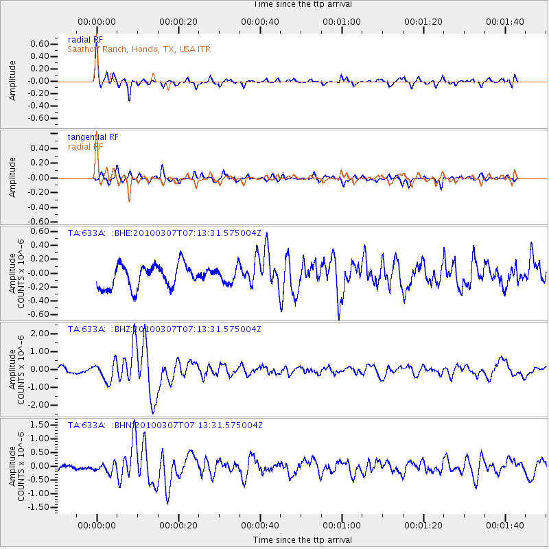
Signal To Noise
| Channel | StoN | STA | LTA |
| TA:633A: :BHZ:20100307T07:13:31.575004Z | 3.1492548 | 5.339047E-7 | 1.6953366E-7 |
| TA:633A: :BHN:20100307T07:13:31.575004Z | 1.3904066 | 1.6146281E-7 | 1.16126316E-7 |
| TA:633A: :BHE:20100307T07:13:31.575004Z | 0.6704151 | 1.1143632E-7 | 1.6621988E-7 |
| Arrivals |
| Ps | 1.8 SECOND |
| PpPs | 6.4 SECOND |
| PsPs/PpSs | 8.1 SECOND |


