You are here: Home > Network List > TX - Texas Seismological Network Stations List
> Station FW03 Perrin-Whitt Elementary School > Earthquake Result Viewer
FW03 Perrin-Whitt Elementary School - Earthquake Result Viewer
| Earthquake location: |
Near Coast Of Peru |
| Earthquake latitude/longitude: |
-15.8/-74.7 |
| Earthquake time(UTC): |
2018/01/14 (014) 09:18:45 GMT |
| Earthquake Depth: |
36 km |
| Earthquake Magnitude: |
7.1 mww |
| Earthquake Catalog/Contributor: |
NEIC PDE/us |
|
| Network: |
TX Texas Seismological Network |
| Station: |
FW03 Perrin-Whitt Elementary School |
| Lat/Lon: |
33.04 N/98.07 W |
| Elevation: |
322 m |
|
| Distance: |
53.4 deg |
| Az: |
335.536 deg |
| Baz: |
151.661 deg |
| Ray Param: |
0.066043 |
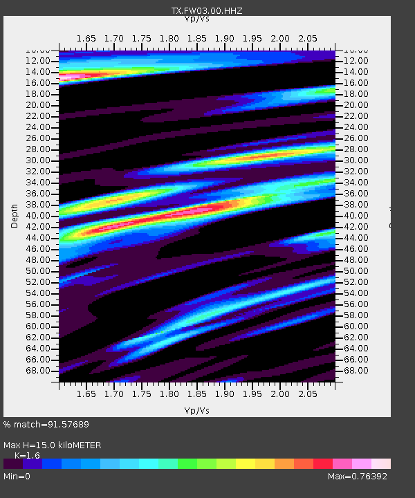
| Estimated Moho Depth: |
15.0 km |
| Estimated Crust Vp/Vs: |
1.60 |
| Assumed Crust Vp: |
6.426 km/s |
| Estimated Crust Vs: |
4.016 km/s |
| Estimated Crust Poisson's Ratio: |
0.18 |
|
| Radial Match: |
91.57689 % |
| Radial Bump: |
337 |
| Transverse Match: |
81.81902 % |
| Transverse Bump: |
380 |
| SOD ConfigId: |
2973751 |
| Insert Time: |
2018-10-09 05:44:24.573 +0000 |
| GWidth: |
2.5 |
| Max Bumps: |
400 |
| Tol: |
0.001 |
|

Signal To Noise
| Channel | StoN | STA | LTA |
| TX:FW03:00:HHZ:20180114T09:27:30.80999Z | 60.55526 | 1.2597612E-5 | 2.0803498E-7 |
| TX:FW03:00:HH1:20180114T09:27:30.80999Z | 15.678111 | 3.9236193E-6 | 2.5026097E-7 |
| TX:FW03:00:HH2:20180114T09:27:30.80999Z | 8.314312 | 1.7860568E-6 | 2.1481715E-7 |
| Arrivals |
| Ps | 1.5 SECOND |
| PpPs | 5.7 SECOND |
| PsPs/PpSs | 7.2 SECOND |


