You are here: Home > Network List > TX - Texas Seismological Network Stations List
> Station FW05 UT at Dallas > Earthquake Result Viewer
FW05 UT at Dallas - Earthquake Result Viewer
| Earthquake location: |
Near Coast Of Peru |
| Earthquake latitude/longitude: |
-15.8/-74.7 |
| Earthquake time(UTC): |
2018/01/14 (014) 09:18:45 GMT |
| Earthquake Depth: |
36 km |
| Earthquake Magnitude: |
7.1 mww |
| Earthquake Catalog/Contributor: |
NEIC PDE/us |
|
| Network: |
TX Texas Seismological Network |
| Station: |
FW05 UT at Dallas |
| Lat/Lon: |
32.99 N/96.75 W |
| Elevation: |
207 m |
|
| Distance: |
52.9 deg |
| Az: |
336.733 deg |
| Baz: |
153.094 deg |
| Ray Param: |
0.066417 |
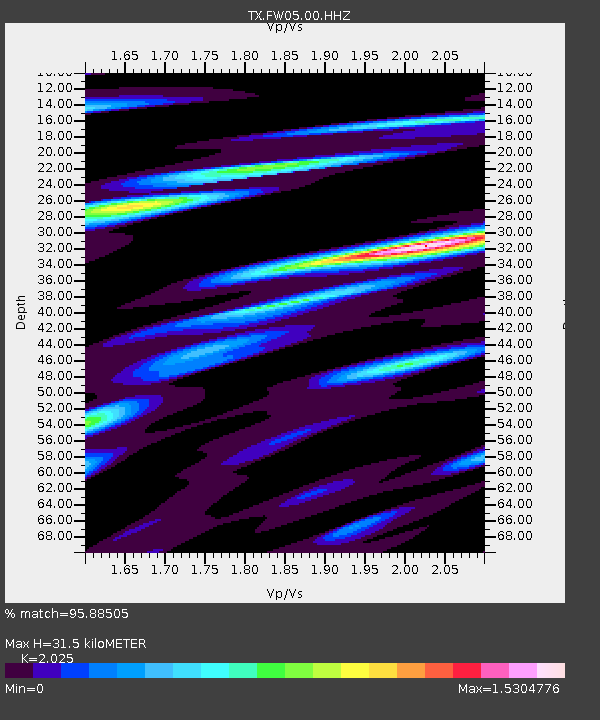
| Estimated Moho Depth: |
31.5 km |
| Estimated Crust Vp/Vs: |
2.03 |
| Assumed Crust Vp: |
6.38 km/s |
| Estimated Crust Vs: |
3.151 km/s |
| Estimated Crust Poisson's Ratio: |
0.34 |
|
| Radial Match: |
95.88505 % |
| Radial Bump: |
304 |
| Transverse Match: |
82.674706 % |
| Transverse Bump: |
400 |
| SOD ConfigId: |
2973751 |
| Insert Time: |
2018-10-09 05:44:24.963 +0000 |
| GWidth: |
2.5 |
| Max Bumps: |
400 |
| Tol: |
0.001 |
|

Signal To Noise
| Channel | StoN | STA | LTA |
| TX:FW05:00:HHZ:20180114T09:27:26.80999Z | 71.78579 | 1.7329188E-5 | 2.4140138E-7 |
| TX:FW05:00:HH1:20180114T09:27:26.80999Z | 14.20831 | 4.985909E-6 | 3.50915E-7 |
| TX:FW05:00:HH2:20180114T09:27:26.80999Z | 6.8794937 | 3.1212371E-6 | 4.5370155E-7 |
| Arrivals |
| Ps | 5.3 SECOND |
| PpPs | 14 SECOND |
| PsPs/PpSs | 20 SECOND |


