You are here: Home > Network List > TX - Texas Seismological Network Stations List
> Station FW11 UT at Arlington > Earthquake Result Viewer
FW11 UT at Arlington - Earthquake Result Viewer
| Earthquake location: |
Near Coast Of Peru |
| Earthquake latitude/longitude: |
-15.8/-74.7 |
| Earthquake time(UTC): |
2018/01/14 (014) 09:18:45 GMT |
| Earthquake Depth: |
36 km |
| Earthquake Magnitude: |
7.1 mww |
| Earthquake Catalog/Contributor: |
NEIC PDE/us |
|
| Network: |
TX Texas Seismological Network |
| Station: |
FW11 UT at Arlington |
| Lat/Lon: |
32.72 N/97.13 W |
| Elevation: |
198 m |
|
| Distance: |
52.8 deg |
| Az: |
336.223 deg |
| Baz: |
152.58 deg |
| Ray Param: |
0.06647702 |
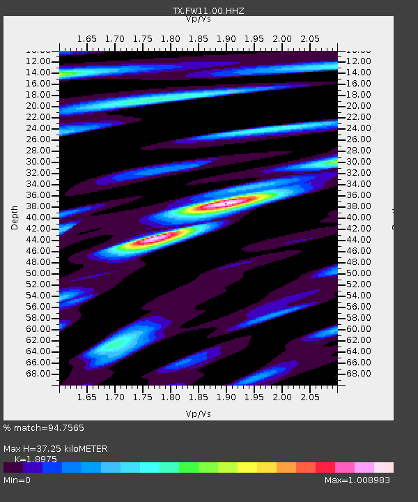
| Estimated Moho Depth: |
37.25 km |
| Estimated Crust Vp/Vs: |
1.90 |
| Assumed Crust Vp: |
6.38 km/s |
| Estimated Crust Vs: |
3.363 km/s |
| Estimated Crust Poisson's Ratio: |
0.31 |
|
| Radial Match: |
94.7565 % |
| Radial Bump: |
327 |
| Transverse Match: |
90.47983 % |
| Transverse Bump: |
350 |
| SOD ConfigId: |
2973751 |
| Insert Time: |
2018-10-09 05:44:31.265 +0000 |
| GWidth: |
2.5 |
| Max Bumps: |
400 |
| Tol: |
0.001 |
|
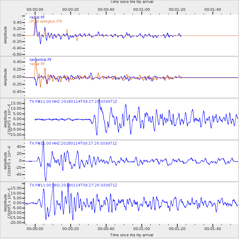
Signal To Noise
| Channel | StoN | STA | LTA |
| TX:FW11:00:HHZ:20180114T09:27:26.039971Z | 65.49502 | 1.8645906E-5 | 2.8469196E-7 |
| TX:FW11:00:HH1:20180114T09:27:26.039971Z | 13.060965 | 4.1778076E-6 | 3.1986977E-7 |
| TX:FW11:00:HH2:20180114T09:27:26.039971Z | 9.324655 | 3.371613E-6 | 3.6158048E-7 |
| Arrivals |
| Ps | 5.5 SECOND |
| PpPs | 16 SECOND |
| PsPs/PpSs | 22 SECOND |


