You are here: Home > Network List > TX - Texas Seismological Network Stations List
> Station FW12 Venus > Earthquake Result Viewer
FW12 Venus - Earthquake Result Viewer
| Earthquake location: |
Near Coast Of Peru |
| Earthquake latitude/longitude: |
-15.8/-74.7 |
| Earthquake time(UTC): |
2018/01/14 (014) 09:18:45 GMT |
| Earthquake Depth: |
36 km |
| Earthquake Magnitude: |
7.1 mww |
| Earthquake Catalog/Contributor: |
NEIC PDE/us |
|
| Network: |
TX Texas Seismological Network |
| Station: |
FW12 Venus |
| Lat/Lon: |
32.50 N/97.15 W |
| Elevation: |
204 m |
|
| Distance: |
52.6 deg |
| Az: |
336.074 deg |
| Baz: |
152.478 deg |
| Ray Param: |
0.06660068 |
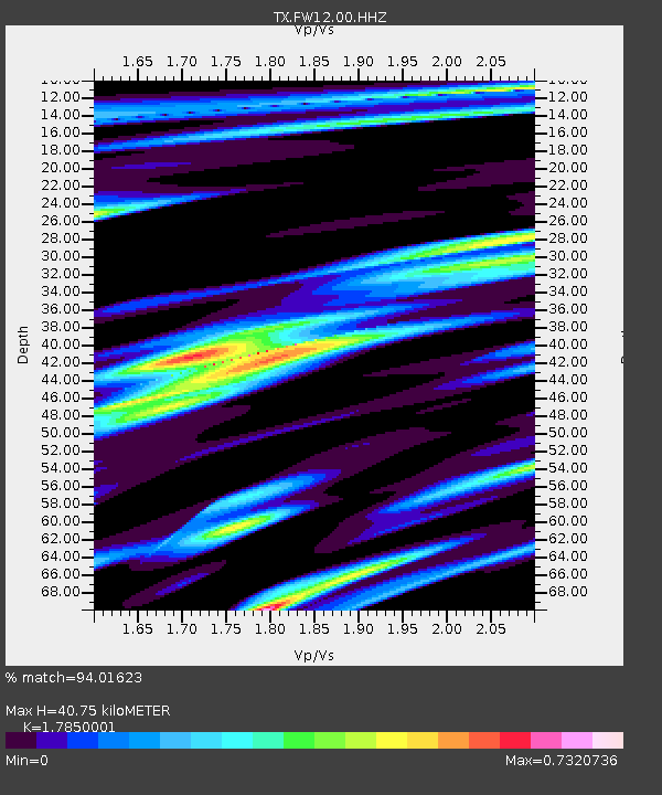
| Estimated Moho Depth: |
40.75 km |
| Estimated Crust Vp/Vs: |
1.79 |
| Assumed Crust Vp: |
6.38 km/s |
| Estimated Crust Vs: |
3.575 km/s |
| Estimated Crust Poisson's Ratio: |
0.27 |
|
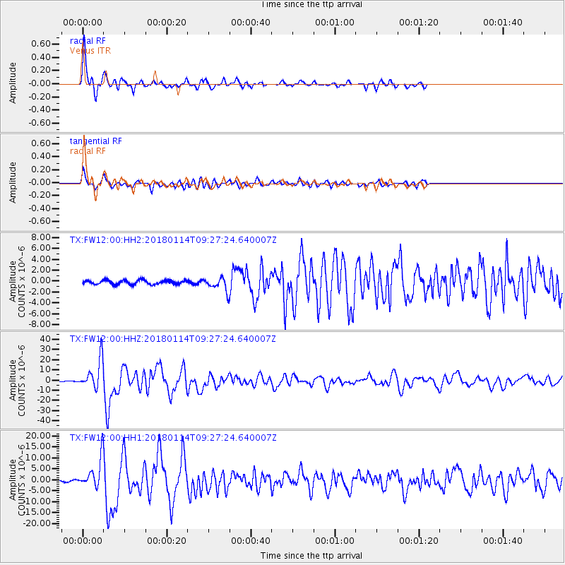
| Radial Match: |
94.01623 % |
| Radial Bump: |
346 |
| Transverse Match: |
84.88722 % |
| Transverse Bump: |
400 |
| SOD ConfigId: |
2973751 |
| Insert Time: |
2018-10-09 05:44:34.984 +0000 |
| GWidth: |
2.5 |
| Max Bumps: |
400 |
| Tol: |
0.001 |
|
Signal To Noise
| Channel | StoN | STA | LTA |
| TX:FW12:00:HHZ:20180114T09:27:24.640007Z | 62.051685 | 1.4710875E-5 | 2.3707454E-7 |
| TX:FW12:00:HH1:20180114T09:27:24.640007Z | 26.559153 | 6.8305585E-6 | 2.5718285E-7 |
| TX:FW12:00:HH2:20180114T09:27:24.640007Z | 2.8265512 | 1.081218E-6 | 3.8252202E-7 |
| Arrivals |
| Ps | 5.3 SECOND |
| PpPs | 17 SECOND |
| PsPs/PpSs | 22 SECOND |


