You are here: Home > Network List > TX - Texas Seismological Network Stations List
> Station FW16 Waxahatchie > Earthquake Result Viewer
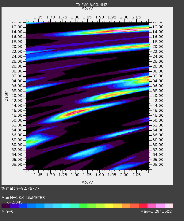
FW16 Waxahatchie - Earthquake Result Viewer
| Earthquake location: |
Near Coast Of Peru |
| Earthquake latitude/longitude: |
-15.8/-74.7 |
| Earthquake time(UTC): |
2018/01/14 (014) 09:18:45 GMT |
| Earthquake Depth: |
36 km |
| Earthquake Magnitude: |
7.1 mww |
| Earthquake Catalog/Contributor: |
NEIC PDE/us |
|
| Network: |
TX Texas Seismological Network |
| Station: |
FW16 Waxahatchie |
| Lat/Lon: |
32.48 N/96.90 W |
| Elevation: |
215 m |
|
| Distance: |
52.5 deg |
| Az: |
336.302 deg |
| Baz: |
152.751 deg |
| Ray Param: |
0.066672854 |
| Estimated Moho Depth: |
13.0 km |
| Estimated Crust Vp/Vs: |
2.05 |
| Assumed Crust Vp: |
6.38 km/s |
| Estimated Crust Vs: |
3.12 km/s |
| Estimated Crust Poisson's Ratio: |
0.34 |
|
| Radial Match: |
92.76777 % |
| Radial Bump: |
400 |
| Transverse Match: |
89.17443 % |
| Transverse Bump: |
400 |
| SOD ConfigId: |
2973751 |
| Insert Time: |
2018-10-09 05:44:38.474 +0000 |
| GWidth: |
2.5 |
| Max Bumps: |
400 |
| Tol: |
0.001 |
|

Signal To Noise
| Channel | StoN | STA | LTA |
| TX:FW16:00:HHZ:20180114T09:27:23.804985Z | 45.555866 | 1.385472E-5 | 3.0412596E-7 |
| TX:FW16:00:HH1:20180114T09:27:23.804985Z | 13.465124 | 4.879824E-6 | 3.6240468E-7 |
| TX:FW16:00:HH2:20180114T09:27:23.804985Z | 4.4240856 | 1.9288007E-6 | 4.3597726E-7 |
| Arrivals |
| Ps | 2.2 SECOND |
| PpPs | 5.9 SECOND |
| PsPs/PpSs | 8.2 SECOND |


