You are here: Home > Network List > TA - USArray Transportable Network (new EarthScope stations) Stations List
> Station 239A Gary, TX, USA > Earthquake Result Viewer
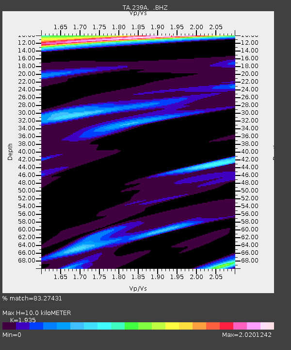
239A Gary, TX, USA - Earthquake Result Viewer
| Earthquake location: |
Southern East Pacific Rise |
| Earthquake latitude/longitude: |
-16.2/-115.3 |
| Earthquake time(UTC): |
2010/03/07 (066) 07:05:23 GMT |
| Earthquake Depth: |
10 km |
| Earthquake Magnitude: |
5.8 MB, 5.7 MS, 6.3 MW, 6.2 MW |
| Earthquake Catalog/Contributor: |
WHDF/NEIC |
|
| Network: |
TA USArray Transportable Network (new EarthScope stations) |
| Station: |
239A Gary, TX, USA |
| Lat/Lon: |
32.02 N/94.47 W |
| Elevation: |
100 m |
|
| Distance: |
52.0 deg |
| Az: |
22.544 deg |
| Baz: |
205.693 deg |
| Ray Param: |
0.0670597 |
| Estimated Moho Depth: |
10.0 km |
| Estimated Crust Vp/Vs: |
1.93 |
| Assumed Crust Vp: |
6.245 km/s |
| Estimated Crust Vs: |
3.227 km/s |
| Estimated Crust Poisson's Ratio: |
0.32 |
|
| Radial Match: |
83.27431 % |
| Radial Bump: |
386 |
| Transverse Match: |
63.004242 % |
| Transverse Bump: |
318 |
| SOD ConfigId: |
299721 |
| Insert Time: |
2010-04-26 18:17:44.091 +0000 |
| GWidth: |
2.5 |
| Max Bumps: |
400 |
| Tol: |
0.001 |
|

Signal To Noise
| Channel | StoN | STA | LTA |
| TA:239A: :BHZ:20100307T07:14:01.500022Z | 3.0039763 | 7.698404E-7 | 2.562738E-7 |
| TA:239A: :BHN:20100307T07:14:01.500022Z | 1.0644201 | 3.5787832E-7 | 3.3621902E-7 |
| TA:239A: :BHE:20100307T07:14:01.500022Z | 1.0995004 | 5.319038E-7 | 4.8376864E-7 |
| Arrivals |
| Ps | 1.6 SECOND |
| PpPs | 4.5 SECOND |
| PsPs/PpSs | 6.0 SECOND |


