You are here: Home > Network List > 1E - GSC-BCOGC Induced Seismicity Study Stations List
> Station MONTE Z > Earthquake Result Viewer
MONTE Z - Earthquake Result Viewer
| Earthquake location: |
Rat Islands, Aleutian Islands |
| Earthquake latitude/longitude: |
51.6/178.6 |
| Earthquake time(UTC): |
2022/12/14 (348) 18:40:26 GMT |
| Earthquake Depth: |
73 km |
| Earthquake Magnitude: |
6.3 Mww |
| Earthquake Catalog/Contributor: |
NEIC PDE/us |
|
| Network: |
1E GSC-BCOGC Induced Seismicity Study |
| Station: |
MONTE Z |
| Lat/Lon: |
57.21 N/122.17 W |
| Elevation: |
0.0 m |
|
| Distance: |
33.9 deg |
| Az: |
56.845 deg |
| Baz: |
286.401 deg |
| Ray Param: |
0.07779109 |
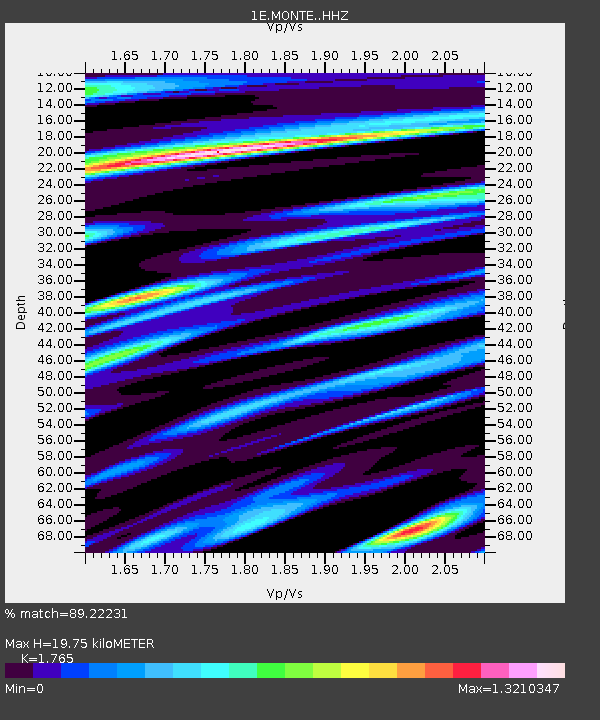
| Estimated Moho Depth: |
19.75 km |
| Estimated Crust Vp/Vs: |
1.76 |
| Assumed Crust Vp: |
6.232 km/s |
| Estimated Crust Vs: |
3.531 km/s |
| Estimated Crust Poisson's Ratio: |
0.26 |
|
| Radial Match: |
89.22231 % |
| Radial Bump: |
400 |
| Transverse Match: |
71.67029 % |
| Transverse Bump: |
400 |
| SOD ConfigId: |
29823551 |
| Insert Time: |
2022-12-28 18:40:54.783 +0000 |
| GWidth: |
2.5 |
| Max Bumps: |
400 |
| Tol: |
0.001 |
|

Signal To Noise
| Channel | StoN | STA | LTA |
| 1E:MONTE: :HHZ:20221214T18:46:32.710007Z | 15.73647 | 9.031601E-6 | 5.73928E-7 |
| 1E:MONTE: :HHN:20221214T18:46:32.710007Z | 4.0391903 | 2.150796E-6 | 5.32482E-7 |
| 1E:MONTE: :HHE:20221214T18:46:32.710007Z | 3.5540953 | 3.887681E-6 | 1.0938595E-6 |
| Arrivals |
| Ps | 2.6 SECOND |
| PpPs | 8.2 SECOND |
| PsPs/PpSs | 11 SECOND |


