You are here: Home > Network List > AE - Arizona Broadband Seismic Network Stations List
> Station HANNA Alpine/Hannagan Meadow > Earthquake Result Viewer
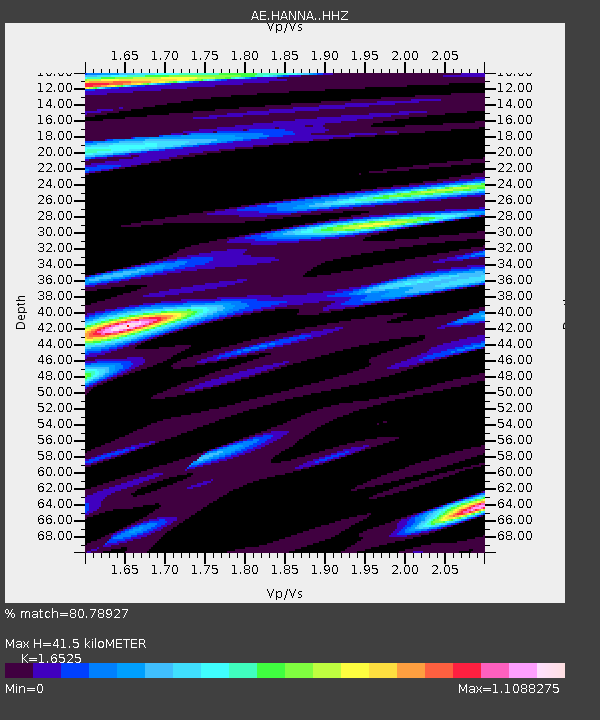
HANNA Alpine/Hannagan Meadow - Earthquake Result Viewer
| Earthquake location: |
Rat Islands, Aleutian Islands |
| Earthquake latitude/longitude: |
51.6/178.6 |
| Earthquake time(UTC): |
2022/12/14 (348) 18:40:26 GMT |
| Earthquake Depth: |
73 km |
| Earthquake Magnitude: |
6.3 Mww |
| Earthquake Catalog/Contributor: |
NEIC PDE/us |
|
| Network: |
AE Arizona Broadband Seismic Network |
| Station: |
HANNA Alpine/Hannagan Meadow |
| Lat/Lon: |
33.64 N/109.32 W |
| Elevation: |
2796 m |
|
| Distance: |
53.8 deg |
| Az: |
79.798 deg |
| Baz: |
312.654 deg |
| Ray Param: |
0.06567937 |
| Estimated Moho Depth: |
41.5 km |
| Estimated Crust Vp/Vs: |
1.65 |
| Assumed Crust Vp: |
6.276 km/s |
| Estimated Crust Vs: |
3.798 km/s |
| Estimated Crust Poisson's Ratio: |
0.21 |
|
| Radial Match: |
80.78927 % |
| Radial Bump: |
400 |
| Transverse Match: |
63.48122 % |
| Transverse Bump: |
400 |
| SOD ConfigId: |
29823551 |
| Insert Time: |
2022-12-28 18:42:04.898 +0000 |
| GWidth: |
2.5 |
| Max Bumps: |
400 |
| Tol: |
0.001 |
|

Signal To Noise
| Channel | StoN | STA | LTA |
| AE:HANNA: :HHZ:20221214T18:49:10.999985Z | 47.188416 | 5.7576535E-6 | 1.2201413E-7 |
| AE:HANNA: :HHN:20221214T18:49:10.999985Z | 9.732842 | 1.4502048E-6 | 1.4900115E-7 |
| AE:HANNA: :HHE:20221214T18:49:10.999985Z | 19.646852 | 1.7967072E-6 | 9.145013E-8 |
| Arrivals |
| Ps | 4.6 SECOND |
| PpPs | 17 SECOND |
| PsPs/PpSs | 21 SECOND |


