You are here: Home > Network List > C0 - Colorado Geological Survey Seismic Network Stations List
> Station SPVA SPVA > Earthquake Result Viewer
SPVA SPVA - Earthquake Result Viewer
| Earthquake location: |
Rat Islands, Aleutian Islands |
| Earthquake latitude/longitude: |
51.6/178.6 |
| Earthquake time(UTC): |
2022/12/14 (348) 18:40:26 GMT |
| Earthquake Depth: |
73 km |
| Earthquake Magnitude: |
6.3 Mww |
| Earthquake Catalog/Contributor: |
NEIC PDE/us |
|
| Network: |
C0 Colorado Geological Survey Seismic Network |
| Station: |
SPVA SPVA |
| Lat/Lon: |
39.47 N/107.22 W |
| Elevation: |
2176 m |
|
| Distance: |
51.2 deg |
| Az: |
72.866 deg |
| Baz: |
309.672 deg |
| Ray Param: |
0.067365766 |
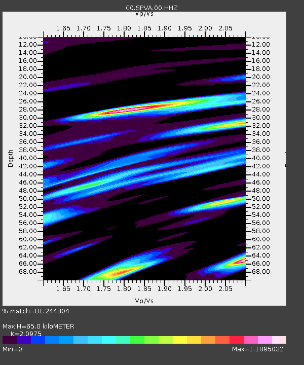
| Estimated Moho Depth: |
65.0 km |
| Estimated Crust Vp/Vs: |
2.10 |
| Assumed Crust Vp: |
6.306 km/s |
| Estimated Crust Vs: |
3.006 km/s |
| Estimated Crust Poisson's Ratio: |
0.35 |
|
| Radial Match: |
81.244804 % |
| Radial Bump: |
400 |
| Transverse Match: |
72.31989 % |
| Transverse Bump: |
400 |
| SOD ConfigId: |
29823551 |
| Insert Time: |
2022-12-28 18:45:28.781 +0000 |
| GWidth: |
2.5 |
| Max Bumps: |
400 |
| Tol: |
0.001 |
|

Signal To Noise
| Channel | StoN | STA | LTA |
| C0:SPVA:00:HHZ:20221214T18:48:52.07399Z | 11.91895 | 2.4551468E-6 | 2.0598682E-7 |
| C0:SPVA:00:HHN:20221214T18:48:52.07399Z | 6.559668 | 9.4286236E-7 | 1.4373629E-7 |
| C0:SPVA:00:HHE:20221214T18:48:52.07399Z | 10.03405 | 1.4648332E-6 | 1.4598625E-7 |
| Arrivals |
| Ps | 12 SECOND |
| PpPs | 31 SECOND |
| PsPs/PpSs | 42 SECOND |


