You are here: Home > Network List > CC - Cascade Chain Volcano Monitoring Stations List
> Station BRSP Barrett Spur > Earthquake Result Viewer
BRSP Barrett Spur - Earthquake Result Viewer
| Earthquake location: |
Rat Islands, Aleutian Islands |
| Earthquake latitude/longitude: |
51.6/178.6 |
| Earthquake time(UTC): |
2022/12/14 (348) 18:40:26 GMT |
| Earthquake Depth: |
73 km |
| Earthquake Magnitude: |
6.3 Mww |
| Earthquake Catalog/Contributor: |
NEIC PDE/us |
|
| Network: |
CC Cascade Chain Volcano Monitoring |
| Station: |
BRSP Barrett Spur |
| Lat/Lon: |
45.40 N/121.71 W |
| Elevation: |
2080 m |
|
| Distance: |
39.0 deg |
| Az: |
74.879 deg |
| Baz: |
301.321 deg |
| Ray Param: |
0.07500021 |
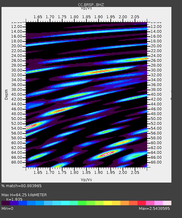
| Estimated Moho Depth: |
64.25 km |
| Estimated Crust Vp/Vs: |
1.93 |
| Assumed Crust Vp: |
6.597 km/s |
| Estimated Crust Vs: |
3.41 km/s |
| Estimated Crust Poisson's Ratio: |
0.32 |
|
| Radial Match: |
80.883965 % |
| Radial Bump: |
400 |
| Transverse Match: |
71.59319 % |
| Transverse Bump: |
400 |
| SOD ConfigId: |
29823551 |
| Insert Time: |
2022-12-28 18:46:17.989 +0000 |
| GWidth: |
2.5 |
| Max Bumps: |
400 |
| Tol: |
0.001 |
|

Signal To Noise
| Channel | StoN | STA | LTA |
| CC:BRSP: :BHZ:20221214T18:47:16.080002Z | 15.776046 | 6.7138035E-6 | 4.2556948E-7 |
| CC:BRSP: :BHN:20221214T18:47:16.080002Z | 8.773765 | 4.4289236E-6 | 5.047917E-7 |
| CC:BRSP: :BHE:20221214T18:47:16.080002Z | 13.972599 | 3.9748375E-6 | 2.844737E-7 |
| Arrivals |
| Ps | 9.8 SECOND |
| PpPs | 27 SECOND |
| PsPs/PpSs | 36 SECOND |


