You are here: Home > Network List > IU - Global Seismograph Network (GSN - IRIS/USGS) Stations List
> Station POHA Pohakuloa, Hawaii, USA > Earthquake Result Viewer
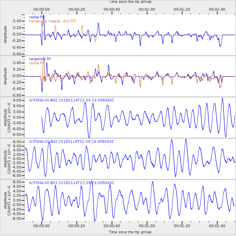
POHA Pohakuloa, Hawaii, USA - Earthquake Result Viewer
*The percent match for this event was below the threshold and hence no stack was calculated.
| Earthquake location: |
Near N Coast Of New Guinea, P.N.G. |
| Earthquake latitude/longitude: |
-4.8/144.9 |
| Earthquake time(UTC): |
2018/01/14 (014) 21:54:36 GMT |
| Earthquake Depth: |
65 km |
| Earthquake Magnitude: |
5.5 Mww |
| Earthquake Catalog/Contributor: |
NEIC PDE/us |
|
| Network: |
IU Global Seismograph Network (GSN - IRIS/USGS) |
| Station: |
POHA Pohakuloa, Hawaii, USA |
| Lat/Lon: |
19.76 N/155.53 W |
| Elevation: |
1990 m |
|
| Distance: |
63.4 deg |
| Az: |
65.242 deg |
| Baz: |
253.908 deg |
| Ray Param: |
$rayparam |
*The percent match for this event was below the threshold and hence was not used in the summary stack. |
|
| Radial Match: |
49.812878 % |
| Radial Bump: |
397 |
| Transverse Match: |
54.98397 % |
| Transverse Bump: |
330 |
| SOD ConfigId: |
2973751 |
| Insert Time: |
2018-10-09 05:47:45.519 +0000 |
| GWidth: |
2.5 |
| Max Bumps: |
400 |
| Tol: |
0.001 |
|
Signal To Noise
| Channel | StoN | STA | LTA |
| IU:POHA:00:BHZ:20180114T22:04:29.068999Z | 1.8844091 | 5.4036127E-6 | 2.867537E-6 |
| IU:POHA:00:BH1:20180114T22:04:29.068999Z | 2.1898386 | 4.670386E-6 | 2.1327535E-6 |
| IU:POHA:00:BH2:20180114T22:04:29.068999Z | 1.2170116 | 3.6765055E-6 | 3.020929E-6 |
| Arrivals |
| Ps | |
| PpPs | |
| PsPs/PpSs | |


