You are here: Home > Network List > GS - US Geological Survey Networks Stations List
> Station ASA3 ASA3 > Earthquake Result Viewer
ASA3 ASA3 - Earthquake Result Viewer
| Earthquake location: |
Rat Islands, Aleutian Islands |
| Earthquake latitude/longitude: |
51.6/178.6 |
| Earthquake time(UTC): |
2022/12/14 (348) 18:40:26 GMT |
| Earthquake Depth: |
73 km |
| Earthquake Magnitude: |
6.3 Mww |
| Earthquake Catalog/Contributor: |
NEIC PDE/us |
|
| Network: |
GS US Geological Survey Networks |
| Station: |
ASA3 ASA3 |
| Lat/Lon: |
34.95 N/106.46 W |
| Elevation: |
1819 m |
|
| Distance: |
54.6 deg |
| Az: |
76.638 deg |
| Baz: |
312.408 deg |
| Ray Param: |
0.06513541 |
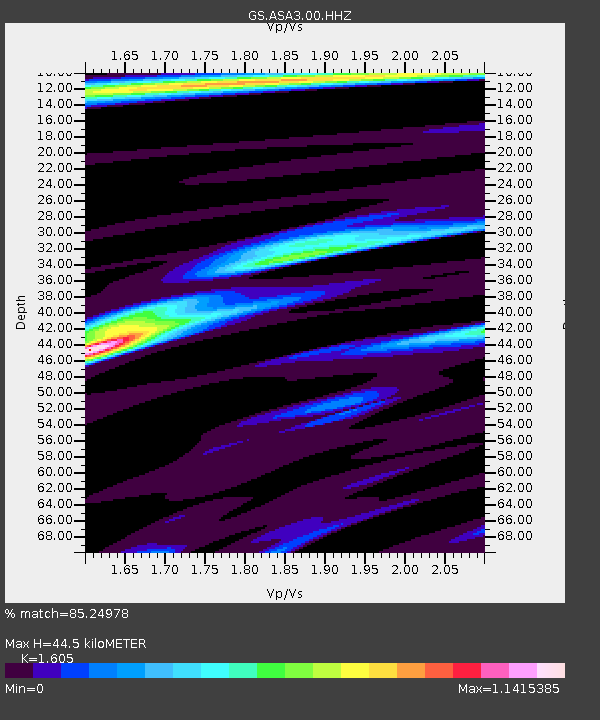
| Estimated Moho Depth: |
44.5 km |
| Estimated Crust Vp/Vs: |
1.61 |
| Assumed Crust Vp: |
6.502 km/s |
| Estimated Crust Vs: |
4.051 km/s |
| Estimated Crust Poisson's Ratio: |
0.18 |
|
| Radial Match: |
85.24978 % |
| Radial Bump: |
380 |
| Transverse Match: |
76.63391 % |
| Transverse Bump: |
400 |
| SOD ConfigId: |
29823551 |
| Insert Time: |
2022-12-28 18:56:56.334 +0000 |
| GWidth: |
2.5 |
| Max Bumps: |
400 |
| Tol: |
0.001 |
|

Signal To Noise
| Channel | StoN | STA | LTA |
| GS:ASA3:00:HHZ:20221214T18:49:17.249008Z | 10.987194 | 3.1849393E-6 | 2.898774E-7 |
| GS:ASA3:00:HH1:20221214T18:49:17.249008Z | 10.067239 | 1.439803E-6 | 1.4301867E-7 |
| GS:ASA3:00:HH2:20221214T18:49:17.249008Z | 9.40297 | 1.3877075E-6 | 1.4758182E-7 |
| Arrivals |
| Ps | 4.4 SECOND |
| PpPs | 17 SECOND |
| PsPs/PpSs | 21 SECOND |


