You are here: Home > Network List > GS - US Geological Survey Networks Stations List
> Station ASA4 ASA4 > Earthquake Result Viewer
ASA4 ASA4 - Earthquake Result Viewer
| Earthquake location: |
Rat Islands, Aleutian Islands |
| Earthquake latitude/longitude: |
51.6/178.6 |
| Earthquake time(UTC): |
2022/12/14 (348) 18:40:26 GMT |
| Earthquake Depth: |
73 km |
| Earthquake Magnitude: |
6.3 Mww |
| Earthquake Catalog/Contributor: |
NEIC PDE/us |
|
| Network: |
GS US Geological Survey Networks |
| Station: |
ASA4 ASA4 |
| Lat/Lon: |
34.94 N/106.46 W |
| Elevation: |
1820 m |
|
| Distance: |
54.6 deg |
| Az: |
76.642 deg |
| Baz: |
312.41 deg |
| Ray Param: |
0.065134324 |
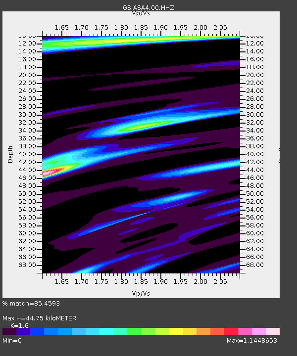
| Estimated Moho Depth: |
44.75 km |
| Estimated Crust Vp/Vs: |
1.60 |
| Assumed Crust Vp: |
6.502 km/s |
| Estimated Crust Vs: |
4.063 km/s |
| Estimated Crust Poisson's Ratio: |
0.18 |
|
| Radial Match: |
85.4593 % |
| Radial Bump: |
377 |
| Transverse Match: |
77.14132 % |
| Transverse Bump: |
400 |
| SOD ConfigId: |
29823551 |
| Insert Time: |
2022-12-28 18:56:59.171 +0000 |
| GWidth: |
2.5 |
| Max Bumps: |
400 |
| Tol: |
0.001 |
|

Signal To Noise
| Channel | StoN | STA | LTA |
| GS:ASA4:00:HHZ:20221214T18:49:17.25798Z | 11.033836 | 3.187169E-6 | 2.8885412E-7 |
| GS:ASA4:00:HH1:20221214T18:49:17.25798Z | 9.655445 | 1.4163369E-6 | 1.466879E-7 |
| GS:ASA4:00:HH2:20221214T18:49:17.25798Z | 9.038891 | 1.4071275E-6 | 1.556748E-7 |
| Arrivals |
| Ps | 4.4 SECOND |
| PpPs | 17 SECOND |
| PsPs/PpSs | 21 SECOND |


