You are here: Home > Network List > TA - USArray Transportable Network (new EarthScope stations) Stations List
> Station M24A Cheyenne, WY, USA > Earthquake Result Viewer
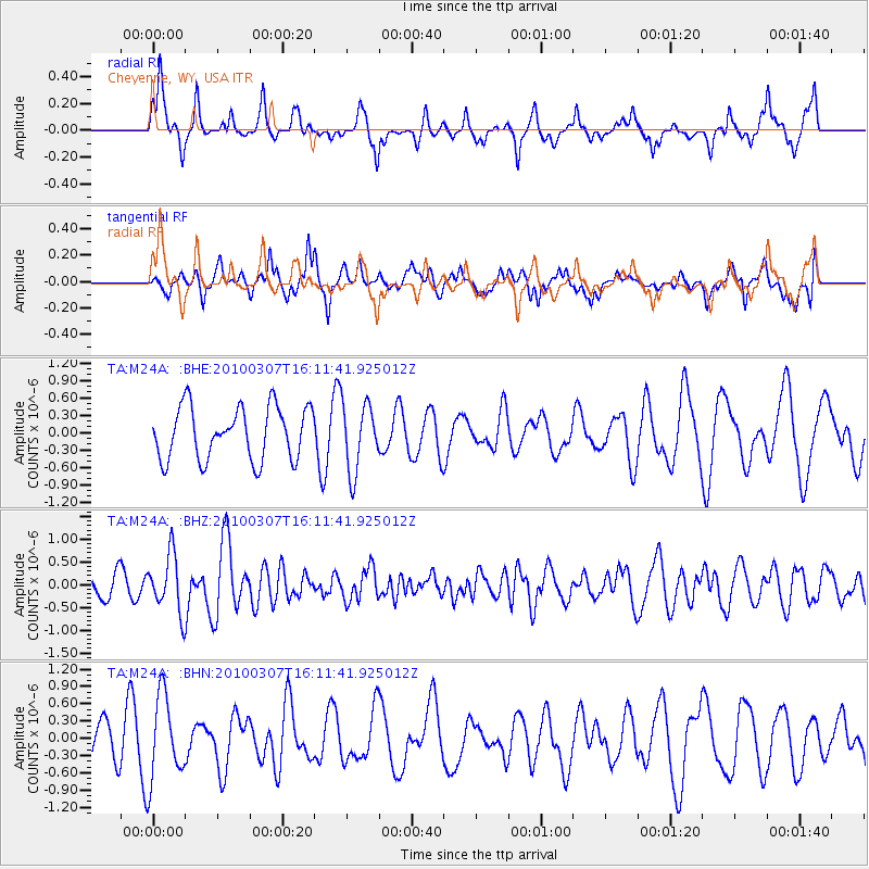
M24A Cheyenne, WY, USA - Earthquake Result Viewer
*The percent match for this event was below the threshold and hence no stack was calculated.
| Earthquake location: |
Near Coast Of Central Chile |
| Earthquake latitude/longitude: |
-38.0/-73.3 |
| Earthquake time(UTC): |
2010/03/07 (066) 15:59:44 GMT |
| Earthquake Depth: |
27 km |
| Earthquake Magnitude: |
5.5 MB, 5.6 MS, 5.8 MW, 5.8 MW |
| Earthquake Catalog/Contributor: |
WHDF/NEIC |
|
| Network: |
TA USArray Transportable Network (new EarthScope stations) |
| Station: |
M24A Cheyenne, WY, USA |
| Lat/Lon: |
41.47 N/104.82 W |
| Elevation: |
1816 m |
|
| Distance: |
84.2 deg |
| Az: |
336.734 deg |
| Baz: |
155.463 deg |
| Ray Param: |
$rayparam |
*The percent match for this event was below the threshold and hence was not used in the summary stack. |
|
| Radial Match: |
54.040844 % |
| Radial Bump: |
310 |
| Transverse Match: |
51.14085 % |
| Transverse Bump: |
362 |
| SOD ConfigId: |
299721 |
| Insert Time: |
2010-04-26 18:29:07.725 +0000 |
| GWidth: |
2.5 |
| Max Bumps: |
400 |
| Tol: |
0.001 |
|
Signal To Noise
| Channel | StoN | STA | LTA |
| TA:M24A: :BHZ:20100307T16:11:41.925012Z | 2.1694133 | 6.3391263E-7 | 2.9220465E-7 |
| TA:M24A: :BHN:20100307T16:11:41.925012Z | 1.5376422 | 7.334911E-7 | 4.7702326E-7 |
| TA:M24A: :BHE:20100307T16:11:41.925012Z | 1.2991335 | 5.87617E-7 | 4.5231457E-7 |
| Arrivals |
| Ps | |
| PpPs | |
| PsPs/PpSs | |


