You are here: Home > Network List > TA - USArray Transportable Network (new EarthScope stations) Stations List
> Station C24A Savage, MT, USA > Earthquake Result Viewer
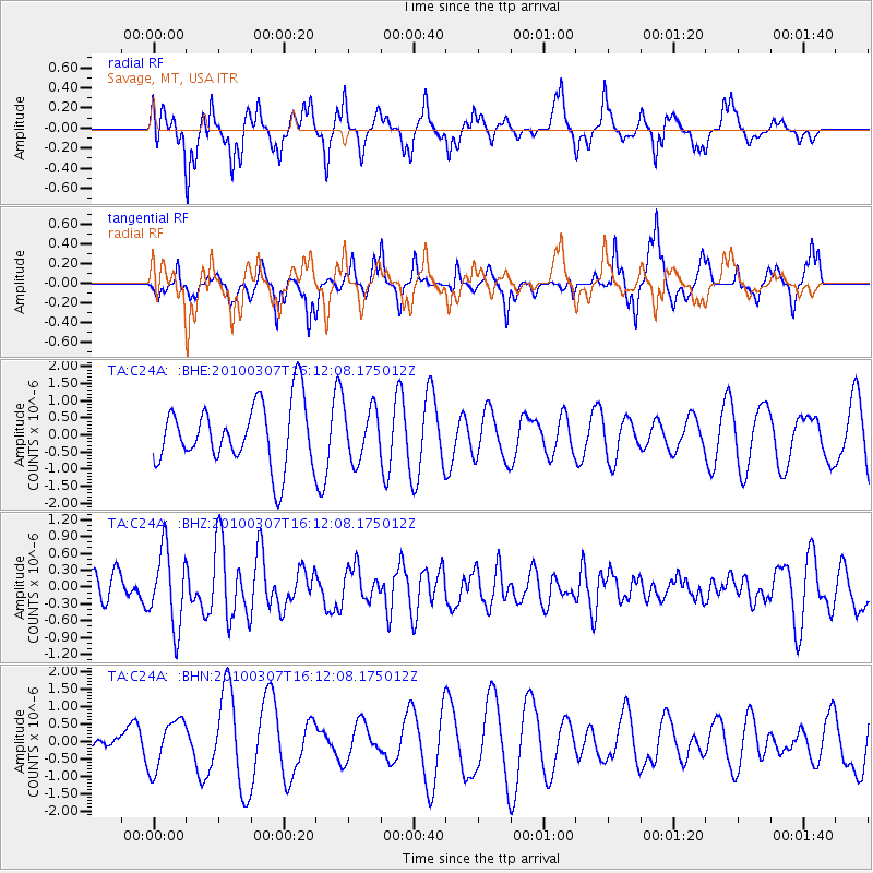
C24A Savage, MT, USA - Earthquake Result Viewer
*The percent match for this event was below the threshold and hence no stack was calculated.
| Earthquake location: |
Near Coast Of Central Chile |
| Earthquake latitude/longitude: |
-38.0/-73.3 |
| Earthquake time(UTC): |
2010/03/07 (066) 15:59:44 GMT |
| Earthquake Depth: |
27 km |
| Earthquake Magnitude: |
5.5 MB, 5.6 MS, 5.8 MW, 5.8 MW |
| Earthquake Catalog/Contributor: |
WHDF/NEIC |
|
| Network: |
TA USArray Transportable Network (new EarthScope stations) |
| Station: |
C24A Savage, MT, USA |
| Lat/Lon: |
47.53 N/104.43 W |
| Elevation: |
713 m |
|
| Distance: |
89.6 deg |
| Az: |
339.494 deg |
| Baz: |
155.894 deg |
| Ray Param: |
$rayparam |
*The percent match for this event was below the threshold and hence was not used in the summary stack. |
|
| Radial Match: |
62.38645 % |
| Radial Bump: |
376 |
| Transverse Match: |
57.213833 % |
| Transverse Bump: |
329 |
| SOD ConfigId: |
299721 |
| Insert Time: |
2010-04-26 18:30:11.411 +0000 |
| GWidth: |
2.5 |
| Max Bumps: |
400 |
| Tol: |
0.001 |
|
Signal To Noise
| Channel | StoN | STA | LTA |
| TA:C24A: :BHZ:20100307T16:12:08.175012Z | 1.5424056 | 6.7627997E-7 | 4.384579E-7 |
| TA:C24A: :BHN:20100307T16:12:08.175012Z | 0.79901004 | 7.0412057E-7 | 8.812412E-7 |
| TA:C24A: :BHE:20100307T16:12:08.175012Z | 0.8285443 | 7.586356E-7 | 9.1562464E-7 |
| Arrivals |
| Ps | |
| PpPs | |
| PsPs/PpSs | |


