You are here: Home > Network List > N4 - Central and EAstern US Network Stations List
> Station WHTX Lake Whitney, Meridian, TX, USA > Earthquake Result Viewer
WHTX Lake Whitney, Meridian, TX, USA - Earthquake Result Viewer
| Earthquake location: |
Rat Islands, Aleutian Islands |
| Earthquake latitude/longitude: |
51.6/178.6 |
| Earthquake time(UTC): |
2022/12/14 (348) 18:40:26 GMT |
| Earthquake Depth: |
73 km |
| Earthquake Magnitude: |
6.3 Mww |
| Earthquake Catalog/Contributor: |
NEIC PDE/us |
|
| Network: |
N4 Central and EAstern US Network |
| Station: |
WHTX Lake Whitney, Meridian, TX, USA |
| Lat/Lon: |
31.99 N/97.46 W |
| Elevation: |
190 m |
|
| Distance: |
62.1 deg |
| Az: |
72.994 deg |
| Baz: |
315.443 deg |
| Ray Param: |
0.060278807 |
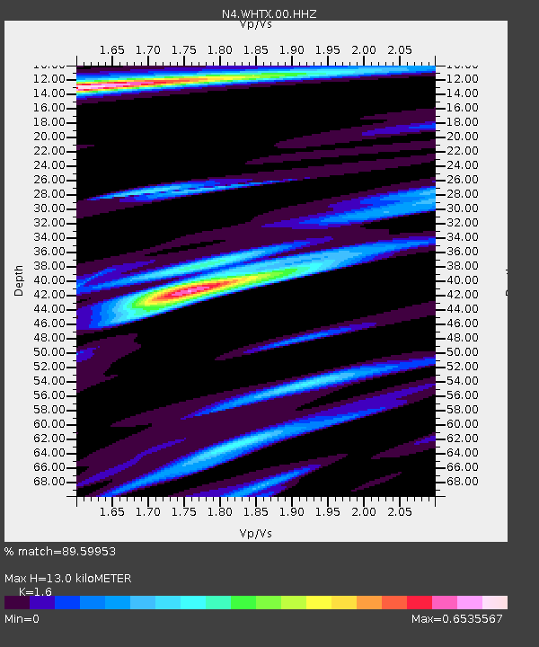
| Estimated Moho Depth: |
13.0 km |
| Estimated Crust Vp/Vs: |
1.60 |
| Assumed Crust Vp: |
6.347 km/s |
| Estimated Crust Vs: |
3.967 km/s |
| Estimated Crust Poisson's Ratio: |
0.18 |
|
| Radial Match: |
89.59953 % |
| Radial Bump: |
384 |
| Transverse Match: |
69.365036 % |
| Transverse Bump: |
400 |
| SOD ConfigId: |
29823551 |
| Insert Time: |
2022-12-28 19:06:05.596 +0000 |
| GWidth: |
2.5 |
| Max Bumps: |
400 |
| Tol: |
0.001 |
|

Signal To Noise
| Channel | StoN | STA | LTA |
| N4:WHTX:00:HHZ:20221214T18:50:09.10997Z | 17.353518 | 4.7241474E-6 | 2.7222995E-7 |
| N4:WHTX:00:HH1:20221214T18:50:09.10997Z | 6.320455 | 1.9526713E-6 | 3.0894472E-7 |
| N4:WHTX:00:HH2:20221214T18:50:09.10997Z | 5.6605916 | 1.6812374E-6 | 2.9700738E-7 |
| Arrivals |
| Ps | 1.3 SECOND |
| PpPs | 5.1 SECOND |
| PsPs/PpSs | 6.4 SECOND |


