You are here: Home > Network List > NN - Western Great Basin/Eastern Sierra Nevada Stations List
> Station GWY Greenwater Valley, CA. (GPS 12/06/2000) w84gm > Earthquake Result Viewer
GWY Greenwater Valley, CA. (GPS 12/06/2000) w84gm - Earthquake Result Viewer
| Earthquake location: |
Rat Islands, Aleutian Islands |
| Earthquake latitude/longitude: |
51.6/178.6 |
| Earthquake time(UTC): |
2022/12/14 (348) 18:40:26 GMT |
| Earthquake Depth: |
73 km |
| Earthquake Magnitude: |
6.3 Mww |
| Earthquake Catalog/Contributor: |
NEIC PDE/us |
|
| Network: |
NN Western Great Basin/Eastern Sierra Nevada |
| Station: |
GWY Greenwater Valley, CA. (GPS 12/06/2000) w84gm |
| Lat/Lon: |
36.19 N/116.67 W |
| Elevation: |
1538 m |
|
| Distance: |
47.5 deg |
| Az: |
82.5 deg |
| Baz: |
310.178 deg |
| Ray Param: |
0.069722906 |
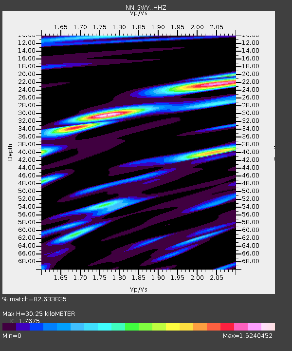
| Estimated Moho Depth: |
30.25 km |
| Estimated Crust Vp/Vs: |
1.77 |
| Assumed Crust Vp: |
6.279 km/s |
| Estimated Crust Vs: |
3.552 km/s |
| Estimated Crust Poisson's Ratio: |
0.26 |
|
| Radial Match: |
82.633835 % |
| Radial Bump: |
400 |
| Transverse Match: |
68.68835 % |
| Transverse Bump: |
400 |
| SOD ConfigId: |
29823551 |
| Insert Time: |
2022-12-28 19:07:42.515 +0000 |
| GWidth: |
2.5 |
| Max Bumps: |
400 |
| Tol: |
0.001 |
|

Signal To Noise
| Channel | StoN | STA | LTA |
| NN:GWY: :HHZ:20221214T18:48:24.367996Z | 32.688858 | 8.037177E-6 | 2.4586902E-7 |
| NN:GWY: :HHN:20221214T18:48:24.367996Z | 6.5378766 | 3.1681843E-6 | 4.845892E-7 |
| NN:GWY: :HHE:20221214T18:48:24.367996Z | 23.02399 | 5.1177653E-6 | 2.222797E-7 |
| Arrivals |
| Ps | 3.9 SECOND |
| PpPs | 13 SECOND |
| PsPs/PpSs | 17 SECOND |


