You are here: Home > Network List > TA - USArray Transportable Network (new EarthScope stations) Stations List
> Station P30A Selden, KS, USA > Earthquake Result Viewer
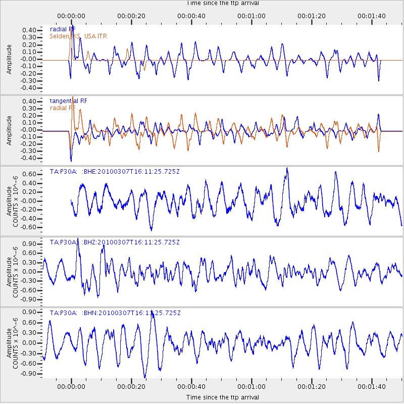
P30A Selden, KS, USA - Earthquake Result Viewer
*The percent match for this event was below the threshold and hence no stack was calculated.
| Earthquake location: |
Near Coast Of Central Chile |
| Earthquake latitude/longitude: |
-38.0/-73.3 |
| Earthquake time(UTC): |
2010/03/07 (066) 15:59:44 GMT |
| Earthquake Depth: |
27 km |
| Earthquake Magnitude: |
5.5 MB, 5.6 MS, 5.8 MW, 5.8 MW |
| Earthquake Catalog/Contributor: |
WHDF/NEIC |
|
| Network: |
TA USArray Transportable Network (new EarthScope stations) |
| Station: |
P30A Selden, KS, USA |
| Lat/Lon: |
39.54 N/100.25 W |
| Elevation: |
788 m |
|
| Distance: |
81.0 deg |
| Az: |
339.223 deg |
| Baz: |
158.747 deg |
| Ray Param: |
$rayparam |
*The percent match for this event was below the threshold and hence was not used in the summary stack. |
|
| Radial Match: |
52.741127 % |
| Radial Bump: |
400 |
| Transverse Match: |
51.08742 % |
| Transverse Bump: |
400 |
| SOD ConfigId: |
299721 |
| Insert Time: |
2010-04-26 18:38:26.279 +0000 |
| GWidth: |
2.5 |
| Max Bumps: |
400 |
| Tol: |
0.001 |
|
Signal To Noise
| Channel | StoN | STA | LTA |
| TA:P30A: :BHZ:20100307T16:11:25.725Z | 2.3381739 | 4.7486193E-7 | 2.0309095E-7 |
| TA:P30A: :BHN:20100307T16:11:25.725Z | 1.2896571 | 3.0079713E-7 | 2.3323807E-7 |
| TA:P30A: :BHE:20100307T16:11:25.725Z | 0.7342527 | 1.4465658E-7 | 1.97012E-7 |
| Arrivals |
| Ps | |
| PpPs | |
| PsPs/PpSs | |


