You are here: Home > Network List > TA - USArray Transportable Network (new EarthScope stations) Stations List
> Station L29A Maesberg Ranch, Thedford, NE, USA > Earthquake Result Viewer
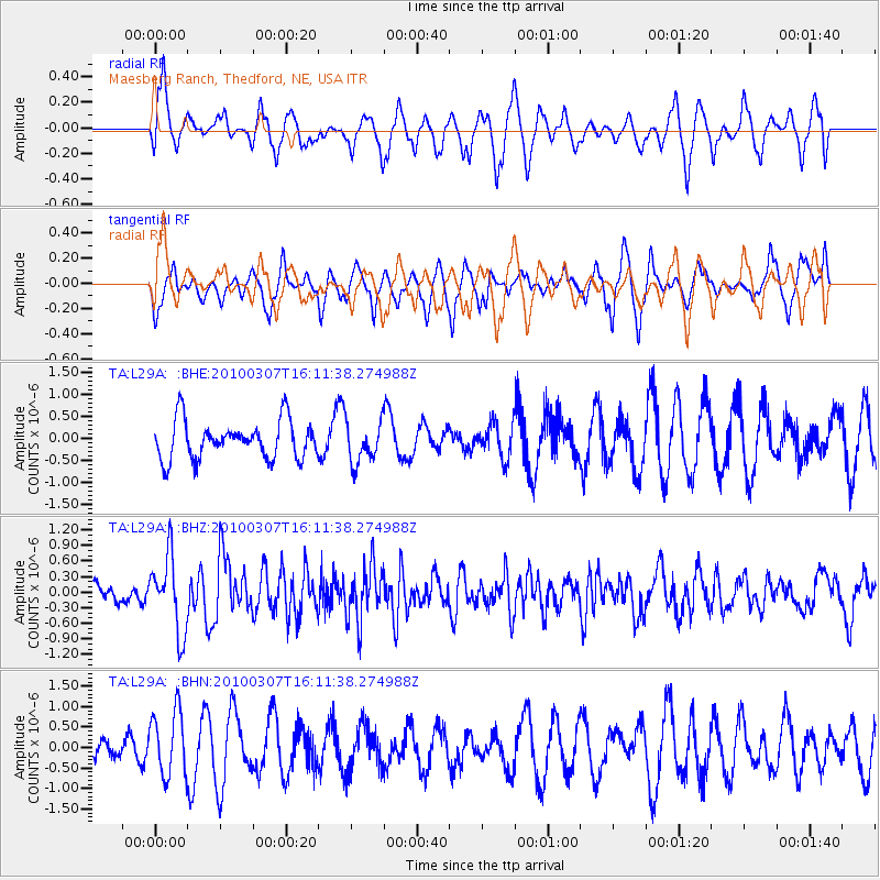
L29A Maesberg Ranch, Thedford, NE, USA - Earthquake Result Viewer
*The percent match for this event was below the threshold and hence no stack was calculated.
| Earthquake location: |
Near Coast Of Central Chile |
| Earthquake latitude/longitude: |
-38.0/-73.3 |
| Earthquake time(UTC): |
2010/03/07 (066) 15:59:44 GMT |
| Earthquake Depth: |
27 km |
| Earthquake Magnitude: |
5.5 MB, 5.6 MS, 5.8 MW, 5.8 MW |
| Earthquake Catalog/Contributor: |
WHDF/NEIC |
|
| Network: |
TA USArray Transportable Network (new EarthScope stations) |
| Station: |
L29A Maesberg Ranch, Thedford, NE, USA |
| Lat/Lon: |
42.06 N/100.48 W |
| Elevation: |
901 m |
|
| Distance: |
83.4 deg |
| Az: |
339.98 deg |
| Baz: |
158.699 deg |
| Ray Param: |
$rayparam |
*The percent match for this event was below the threshold and hence was not used in the summary stack. |
|
| Radial Match: |
60.633114 % |
| Radial Bump: |
362 |
| Transverse Match: |
65.62602 % |
| Transverse Bump: |
400 |
| SOD ConfigId: |
299721 |
| Insert Time: |
2010-04-26 18:39:00.301 +0000 |
| GWidth: |
2.5 |
| Max Bumps: |
400 |
| Tol: |
0.001 |
|
Signal To Noise
| Channel | StoN | STA | LTA |
| TA:L29A: :BHZ:20100307T16:11:38.274988Z | 4.850868 | 7.3005896E-7 | 1.5050067E-7 |
| TA:L29A: :BHN:20100307T16:11:38.274988Z | 1.5288861 | 8.051411E-7 | 5.2661943E-7 |
| TA:L29A: :BHE:20100307T16:11:38.274988Z | 1.05316 | 4.5778657E-7 | 4.3467904E-7 |
| Arrivals |
| Ps | |
| PpPs | |
| PsPs/PpSs | |


