You are here: Home > Network List > UO - University of Oregon Regional Network Stations List
> Station VINO Umpqua, OR, USA > Earthquake Result Viewer
VINO Umpqua, OR, USA - Earthquake Result Viewer
| Earthquake location: |
Rat Islands, Aleutian Islands |
| Earthquake latitude/longitude: |
51.6/178.6 |
| Earthquake time(UTC): |
2022/12/14 (348) 18:40:26 GMT |
| Earthquake Depth: |
73 km |
| Earthquake Magnitude: |
6.3 Mww |
| Earthquake Catalog/Contributor: |
NEIC PDE/us |
|
| Network: |
UO University of Oregon Regional Network |
| Station: |
VINO Umpqua, OR, USA |
| Lat/Lon: |
43.43 N/123.42 W |
| Elevation: |
319 m |
|
| Distance: |
39.1 deg |
| Az: |
78.567 deg |
| Baz: |
302.99 deg |
| Ray Param: |
0.07499377 |
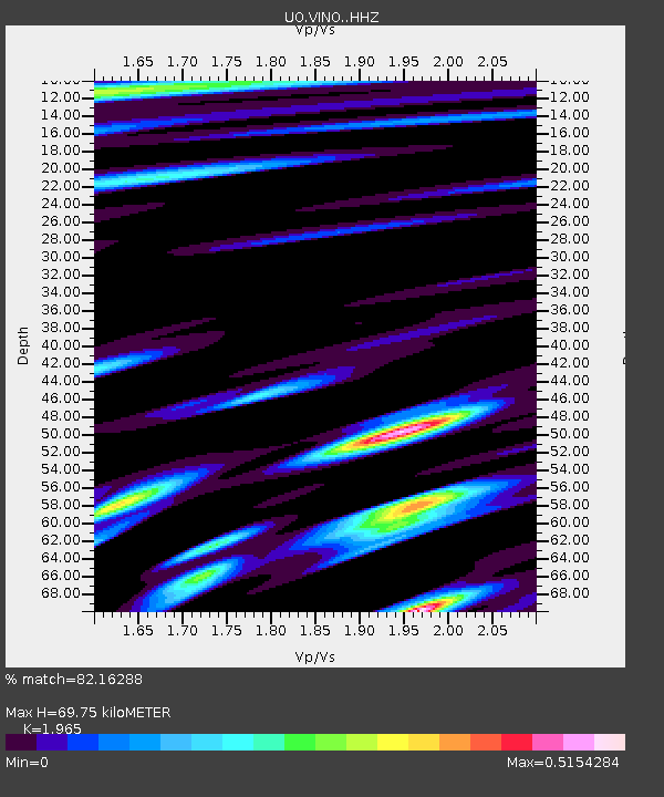
| Estimated Moho Depth: |
69.75 km |
| Estimated Crust Vp/Vs: |
1.97 |
| Assumed Crust Vp: |
6.522 km/s |
| Estimated Crust Vs: |
3.319 km/s |
| Estimated Crust Poisson's Ratio: |
0.33 |
|
| Radial Match: |
82.16288 % |
| Radial Bump: |
400 |
| Transverse Match: |
80.72453 % |
| Transverse Bump: |
400 |
| SOD ConfigId: |
29823551 |
| Insert Time: |
2022-12-28 19:21:54.729 +0000 |
| GWidth: |
2.5 |
| Max Bumps: |
400 |
| Tol: |
0.001 |
|

Signal To Noise
| Channel | StoN | STA | LTA |
| UO:VINO: :HHZ:20221214T18:47:16.169998Z | 38.138626 | 1.3471624E-5 | 3.5322782E-7 |
| UO:VINO: :HHN:20221214T18:47:16.169998Z | 4.9120345 | 2.1627475E-6 | 4.4029562E-7 |
| UO:VINO: :HHE:20221214T18:47:16.169998Z | 9.410073 | 2.2116988E-6 | 2.3503524E-7 |
| Arrivals |
| Ps | 11 SECOND |
| PpPs | 30 SECOND |
| PsPs/PpSs | 41 SECOND |


