You are here: Home > Network List > US - United States National Seismic Network Stations List
> Station MSO Missoula, Montana, USA > Earthquake Result Viewer
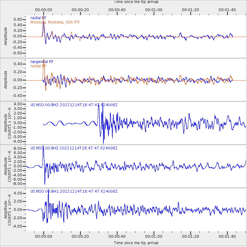
MSO Missoula, Montana, USA - Earthquake Result Viewer
*The percent match for this event was below the threshold and hence no stack was calculated.
| Earthquake location: |
Rat Islands, Aleutian Islands |
| Earthquake latitude/longitude: |
51.6/178.6 |
| Earthquake time(UTC): |
2022/12/14 (348) 18:40:26 GMT |
| Earthquake Depth: |
73 km |
| Earthquake Magnitude: |
6.3 Mww |
| Earthquake Catalog/Contributor: |
NEIC PDE/us |
|
| Network: |
US United States National Seismic Network |
| Station: |
MSO Missoula, Montana, USA |
| Lat/Lon: |
46.83 N/113.94 W |
| Elevation: |
1264 m |
|
| Distance: |
42.9 deg |
| Az: |
68.692 deg |
| Baz: |
302.23 deg |
| Ray Param: |
$rayparam |
*The percent match for this event was below the threshold and hence was not used in the summary stack. |
|
| Radial Match: |
76.68045 % |
| Radial Bump: |
400 |
| Transverse Match: |
77.7076 % |
| Transverse Bump: |
400 |
| SOD ConfigId: |
29823551 |
| Insert Time: |
2022-12-28 19:23:17.210 +0000 |
| GWidth: |
2.5 |
| Max Bumps: |
400 |
| Tol: |
0.001 |
|
Signal To Noise
| Channel | StoN | STA | LTA |
| US:MSO:00:BHZ:20221214T18:47:47.624008Z | 6.293866 | 3.557484E-6 | 5.6523027E-7 |
| US:MSO:00:BH1:20221214T18:47:47.624008Z | 10.947865 | 1.78929E-6 | 1.6343736E-7 |
| US:MSO:00:BH2:20221214T18:47:47.624008Z | 8.038348 | 2.0326934E-6 | 2.528745E-7 |
| Arrivals |
| Ps | |
| PpPs | |
| PsPs/PpSs | |


