You are here: Home > Network List > UU - University of Utah Regional Network Stations List
> Station CCUT Cedar City, UT, USA > Earthquake Result Viewer
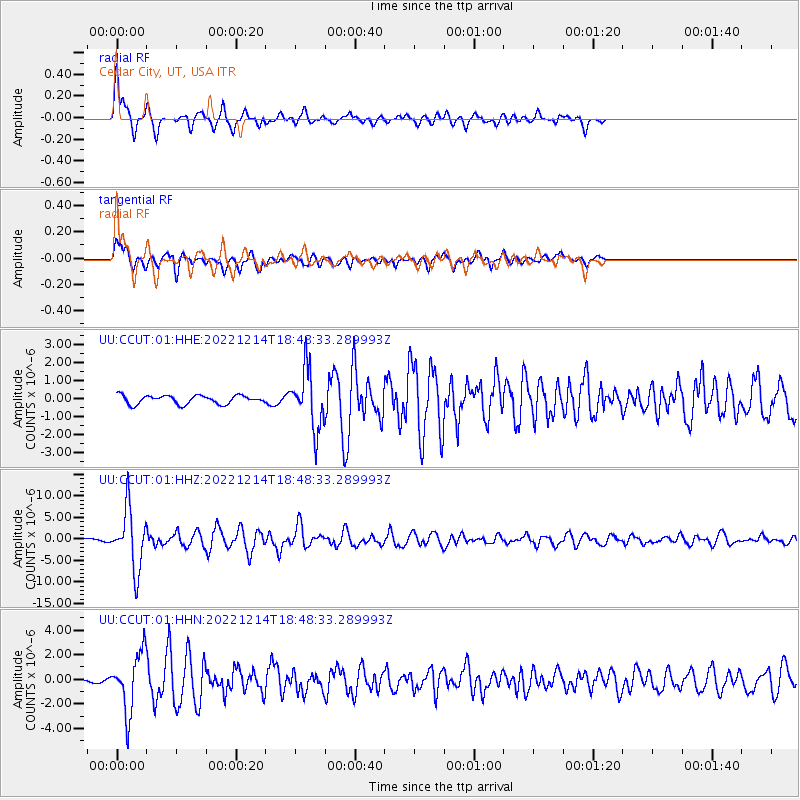
CCUT Cedar City, UT, USA - Earthquake Result Viewer
*The percent match for this event was below the threshold and hence no stack was calculated.
| Earthquake location: |
Rat Islands, Aleutian Islands |
| Earthquake latitude/longitude: |
51.6/178.6 |
| Earthquake time(UTC): |
2022/12/14 (348) 18:40:26 GMT |
| Earthquake Depth: |
73 km |
| Earthquake Magnitude: |
6.3 Mww |
| Earthquake Catalog/Contributor: |
NEIC PDE/us |
|
| Network: |
UU University of Utah Regional Network |
| Station: |
CCUT Cedar City, UT, USA |
| Lat/Lon: |
37.55 N/113.36 W |
| Elevation: |
2127 m |
|
| Distance: |
48.7 deg |
| Az: |
78.811 deg |
| Baz: |
309.691 deg |
| Ray Param: |
$rayparam |
*The percent match for this event was below the threshold and hence was not used in the summary stack. |
|
| Radial Match: |
78.10375 % |
| Radial Bump: |
400 |
| Transverse Match: |
78.704025 % |
| Transverse Bump: |
400 |
| SOD ConfigId: |
29823551 |
| Insert Time: |
2022-12-28 19:23:54.456 +0000 |
| GWidth: |
2.5 |
| Max Bumps: |
400 |
| Tol: |
0.001 |
|
Signal To Noise
| Channel | StoN | STA | LTA |
| UU:CCUT:01:HHZ:20221214T18:48:33.289993Z | 40.934486 | 6.9184944E-6 | 1.6901383E-7 |
| UU:CCUT:01:HHN:20221214T18:48:33.289993Z | 10.218557 | 2.370692E-6 | 2.3199871E-7 |
| UU:CCUT:01:HHE:20221214T18:48:33.289993Z | 6.6451035 | 1.5960806E-6 | 2.40189E-7 |
| Arrivals |
| Ps | |
| PpPs | |
| PsPs/PpSs | |


