You are here: Home > Network List > UU - University of Utah Regional Network Stations List
> Station FOR6 FORGE > Earthquake Result Viewer
FOR6 FORGE - Earthquake Result Viewer
| Earthquake location: |
Rat Islands, Aleutian Islands |
| Earthquake latitude/longitude: |
51.6/178.6 |
| Earthquake time(UTC): |
2022/12/14 (348) 18:40:26 GMT |
| Earthquake Depth: |
73 km |
| Earthquake Magnitude: |
6.3 Mww |
| Earthquake Catalog/Contributor: |
NEIC PDE/us |
|
| Network: |
UU University of Utah Regional Network |
| Station: |
FOR6 FORGE |
| Lat/Lon: |
38.49 N/112.79 W |
| Elevation: |
2421 m |
|
| Distance: |
48.5 deg |
| Az: |
77.461 deg |
| Baz: |
309.15 deg |
| Ray Param: |
0.06912695 |
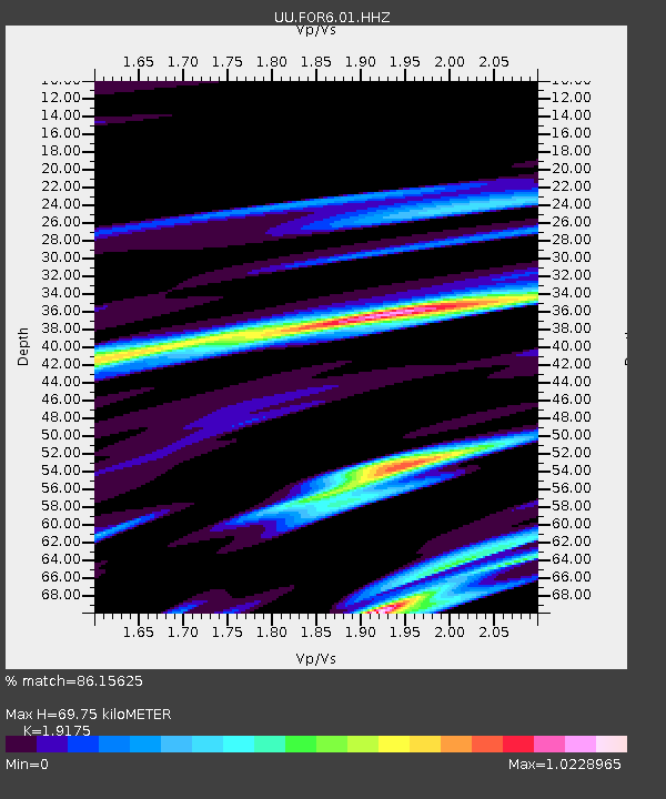
| Estimated Moho Depth: |
69.75 km |
| Estimated Crust Vp/Vs: |
1.92 |
| Assumed Crust Vp: |
6.276 km/s |
| Estimated Crust Vs: |
3.273 km/s |
| Estimated Crust Poisson's Ratio: |
0.31 |
|
| Radial Match: |
86.15625 % |
| Radial Bump: |
400 |
| Transverse Match: |
80.8592 % |
| Transverse Bump: |
400 |
| SOD ConfigId: |
29823551 |
| Insert Time: |
2022-12-28 19:24:04.990 +0000 |
| GWidth: |
2.5 |
| Max Bumps: |
400 |
| Tol: |
0.001 |
|

Signal To Noise
| Channel | StoN | STA | LTA |
| UU:FOR6:01:HHZ:20221214T18:48:31.414993Z | 37.390427 | 6.9278226E-6 | 1.8528333E-7 |
| UU:FOR6:01:HHN:20221214T18:48:31.414993Z | 15.758879 | 5.3626163E-6 | 3.4029173E-7 |
| UU:FOR6:01:HHE:20221214T18:48:31.414993Z | 8.467523 | 3.1364766E-6 | 3.7041252E-7 |
| Arrivals |
| Ps | 11 SECOND |
| PpPs | 31 SECOND |
| PsPs/PpSs | 42 SECOND |


