You are here: Home > Network List > UU - University of Utah Regional Network Stations List
> Station MOUT Mount Ogden, UT, USA > Earthquake Result Viewer
MOUT Mount Ogden, UT, USA - Earthquake Result Viewer
| Earthquake location: |
Rat Islands, Aleutian Islands |
| Earthquake latitude/longitude: |
51.6/178.6 |
| Earthquake time(UTC): |
2022/12/14 (348) 18:40:26 GMT |
| Earthquake Depth: |
73 km |
| Earthquake Magnitude: |
6.3 Mww |
| Earthquake Catalog/Contributor: |
NEIC PDE/us |
|
| Network: |
UU University of Utah Regional Network |
| Station: |
MOUT Mount Ogden, UT, USA |
| Lat/Lon: |
41.20 N/111.88 W |
| Elevation: |
2748 m |
|
| Distance: |
47.3 deg |
| Az: |
74.014 deg |
| Baz: |
307.419 deg |
| Ray Param: |
0.06985308 |
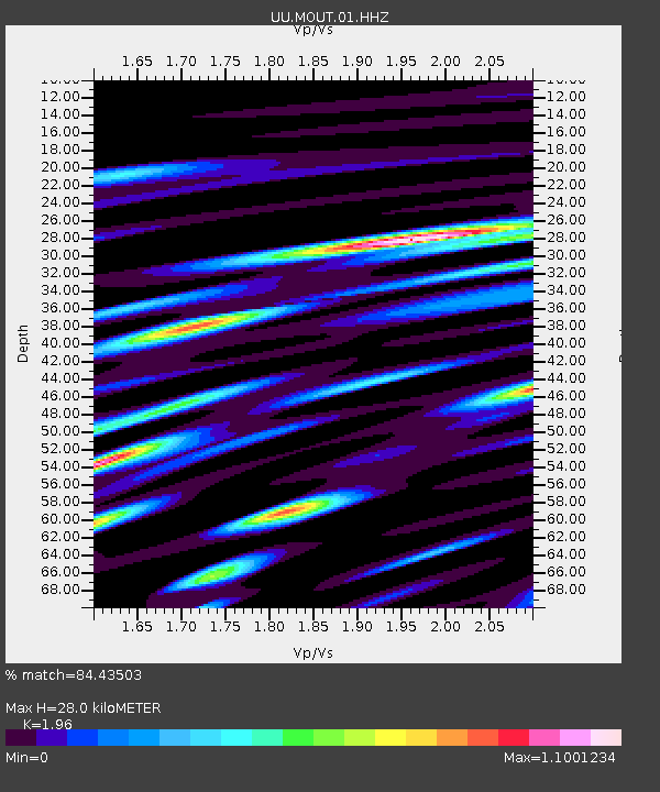
| Estimated Moho Depth: |
28.0 km |
| Estimated Crust Vp/Vs: |
1.96 |
| Assumed Crust Vp: |
6.155 km/s |
| Estimated Crust Vs: |
3.14 km/s |
| Estimated Crust Poisson's Ratio: |
0.32 |
|
| Radial Match: |
84.43503 % |
| Radial Bump: |
400 |
| Transverse Match: |
68.886406 % |
| Transverse Bump: |
400 |
| SOD ConfigId: |
29823551 |
| Insert Time: |
2022-12-28 19:24:26.525 +0000 |
| GWidth: |
2.5 |
| Max Bumps: |
400 |
| Tol: |
0.001 |
|

Signal To Noise
| Channel | StoN | STA | LTA |
| UU:MOUT:01:HHZ:20221214T18:48:22.719986Z | 10.706452 | 3.4301931E-6 | 3.203856E-7 |
| UU:MOUT:01:HHN:20221214T18:48:22.719986Z | 6.349231 | 1.2048669E-6 | 1.897658E-7 |
| UU:MOUT:01:HHE:20221214T18:48:22.719986Z | 5.3112097 | 2.111002E-6 | 3.9746163E-7 |
| Arrivals |
| Ps | 4.6 SECOND |
| PpPs | 13 SECOND |
| PsPs/PpSs | 17 SECOND |


