You are here: Home > Network List > UW - Pacific Northwest Regional Seismic Network Stations List
> Station DATON Dayton, WA, USA > Earthquake Result Viewer
DATON Dayton, WA, USA - Earthquake Result Viewer
| Earthquake location: |
Rat Islands, Aleutian Islands |
| Earthquake latitude/longitude: |
51.6/178.6 |
| Earthquake time(UTC): |
2022/12/14 (348) 18:40:26 GMT |
| Earthquake Depth: |
73 km |
| Earthquake Magnitude: |
6.3 Mww |
| Earthquake Catalog/Contributor: |
NEIC PDE/us |
|
| Network: |
UW Pacific Northwest Regional Seismic Network |
| Station: |
DATON Dayton, WA, USA |
| Lat/Lon: |
46.26 N/117.93 W |
| Elevation: |
815 m |
|
| Distance: |
40.9 deg |
| Az: |
71.587 deg |
| Baz: |
301.501 deg |
| Ray Param: |
0.07392486 |
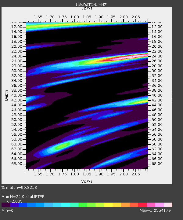
| Estimated Moho Depth: |
24.0 km |
| Estimated Crust Vp/Vs: |
2.04 |
| Assumed Crust Vp: |
6.571 km/s |
| Estimated Crust Vs: |
3.229 km/s |
| Estimated Crust Poisson's Ratio: |
0.34 |
|
| Radial Match: |
90.8213 % |
| Radial Bump: |
347 |
| Transverse Match: |
59.16631 % |
| Transverse Bump: |
400 |
| SOD ConfigId: |
29823551 |
| Insert Time: |
2022-12-28 19:25:28.343 +0000 |
| GWidth: |
2.5 |
| Max Bumps: |
400 |
| Tol: |
0.001 |
|

Signal To Noise
| Channel | StoN | STA | LTA |
| UW:DATON: :HHZ:20221214T18:47:31.030014Z | 16.55584 | 3.6708277E-6 | 2.2172406E-7 |
| UW:DATON: :HHN:20221214T18:47:31.030014Z | 4.9224725 | 1.1722677E-6 | 2.3814611E-7 |
| UW:DATON: :HHE:20221214T18:47:31.030014Z | 6.988051 | 1.8190999E-6 | 2.6031577E-7 |
| Arrivals |
| Ps | 4.0 SECOND |
| PpPs | 10 SECOND |
| PsPs/PpSs | 14 SECOND |


