You are here: Home > Network List > CB - China National Seismic Network Stations List
> Station NJ2 Nanjing,Jiangsu Province > Earthquake Result Viewer
NJ2 Nanjing,Jiangsu Province - Earthquake Result Viewer
| Earthquake location: |
Gulf Of Alaska |
| Earthquake latitude/longitude: |
56.0/-149.1 |
| Earthquake time(UTC): |
2018/01/23 (023) 09:31:42 GMT |
| Earthquake Depth: |
25 km |
| Earthquake Magnitude: |
7.9 Mww |
| Earthquake Catalog/Contributor: |
NEIC PDE/us |
|
| Network: |
CB China National Seismic Network |
| Station: |
NJ2 Nanjing,Jiangsu Province |
| Lat/Lon: |
32.05 N/118.85 E |
| Elevation: |
45 m |
|
| Distance: |
65.2 deg |
| Az: |
290.765 deg |
| Baz: |
38.159 deg |
| Ray Param: |
0.05841398 |
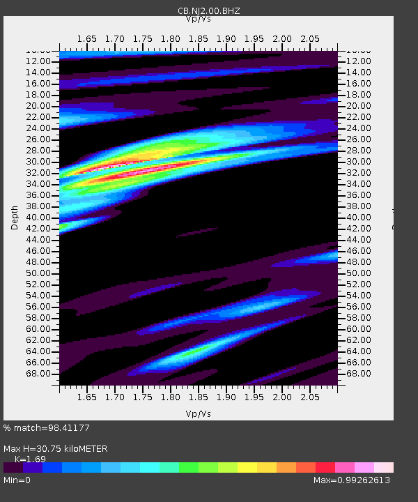
| Estimated Moho Depth: |
30.75 km |
| Estimated Crust Vp/Vs: |
1.69 |
| Assumed Crust Vp: |
6.276 km/s |
| Estimated Crust Vs: |
3.713 km/s |
| Estimated Crust Poisson's Ratio: |
0.23 |
|
| Radial Match: |
98.41177 % |
| Radial Bump: |
305 |
| Transverse Match: |
86.70203 % |
| Transverse Bump: |
400 |
| SOD ConfigId: |
2973751 |
| Insert Time: |
2018-10-09 06:08:49.821 +0000 |
| GWidth: |
2.5 |
| Max Bumps: |
400 |
| Tol: |
0.001 |
|
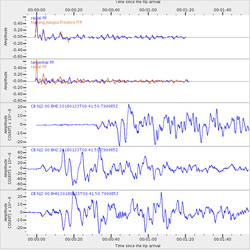
Signal To Noise
| Channel | StoN | STA | LTA |
| CB:NJ2:00:BHZ:20180123T09:41:50.799985Z | 15.667085 | 6.248906E-6 | 3.9885572E-7 |
| CB:NJ2:00:BHN:20180123T09:41:50.799985Z | 7.397695 | 2.0779648E-6 | 2.8089354E-7 |
| CB:NJ2:00:BHE:20180123T09:41:50.799985Z | 7.5764847 | 1.8488116E-6 | 2.440197E-7 |
| Arrivals |
| Ps | 3.5 SECOND |
| PpPs | 13 SECOND |
| PsPs/PpSs | 16 SECOND |


