You are here: Home > Network List > CB - China National Seismic Network Stations List
> Station WHN Wuhantai,Hubei Province > Earthquake Result Viewer
WHN Wuhantai,Hubei Province - Earthquake Result Viewer
| Earthquake location: |
Gulf Of Alaska |
| Earthquake latitude/longitude: |
56.0/-149.1 |
| Earthquake time(UTC): |
2018/01/23 (023) 09:31:42 GMT |
| Earthquake Depth: |
25 km |
| Earthquake Magnitude: |
7.9 Mww |
| Earthquake Catalog/Contributor: |
NEIC PDE/us |
|
| Network: |
CB China National Seismic Network |
| Station: |
WHN Wuhantai,Hubei Province |
| Lat/Lon: |
30.54 N/114.35 E |
| Elevation: |
80 m |
|
| Distance: |
68.7 deg |
| Az: |
293.094 deg |
| Baz: |
36.745 deg |
| Ray Param: |
0.056095835 |
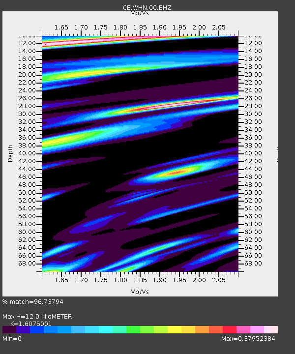
| Estimated Moho Depth: |
12.0 km |
| Estimated Crust Vp/Vs: |
1.61 |
| Assumed Crust Vp: |
6.276 km/s |
| Estimated Crust Vs: |
3.904 km/s |
| Estimated Crust Poisson's Ratio: |
0.18 |
|
| Radial Match: |
96.73794 % |
| Radial Bump: |
351 |
| Transverse Match: |
86.29692 % |
| Transverse Bump: |
400 |
| SOD ConfigId: |
2973751 |
| Insert Time: |
2018-10-09 06:08:54.377 +0000 |
| GWidth: |
2.5 |
| Max Bumps: |
400 |
| Tol: |
0.001 |
|

Signal To Noise
| Channel | StoN | STA | LTA |
| CB:WHN:00:BHZ:20180123T09:42:13.220029Z | 13.138881 | 7.272189E-6 | 5.534862E-7 |
| CB:WHN:00:BHN:20180123T09:42:13.220029Z | 5.417965 | 2.3100106E-6 | 4.263613E-7 |
| CB:WHN:00:BHE:20180123T09:42:13.220029Z | 6.6323047 | 2.00303E-6 | 3.0201116E-7 |
| Arrivals |
| Ps | 1.2 SECOND |
| PpPs | 4.8 SECOND |
| PsPs/PpSs | 6.0 SECOND |


