You are here: Home > Network List > CB - China National Seismic Network Stations List
> Station XLT Xilinhaote,Neimeng Province > Earthquake Result Viewer
XLT Xilinhaote,Neimeng Province - Earthquake Result Viewer
| Earthquake location: |
Gulf Of Alaska |
| Earthquake latitude/longitude: |
56.0/-149.1 |
| Earthquake time(UTC): |
2018/01/23 (023) 09:31:42 GMT |
| Earthquake Depth: |
25 km |
| Earthquake Magnitude: |
7.9 Mww |
| Earthquake Catalog/Contributor: |
NEIC PDE/us |
|
| Network: |
CB China National Seismic Network |
| Station: |
XLT Xilinhaote,Neimeng Province |
| Lat/Lon: |
43.90 N/116.08 E |
| Elevation: |
1030 m |
|
| Distance: |
57.5 deg |
| Az: |
301.32 deg |
| Baz: |
41.537 deg |
| Ray Param: |
0.06343165 |
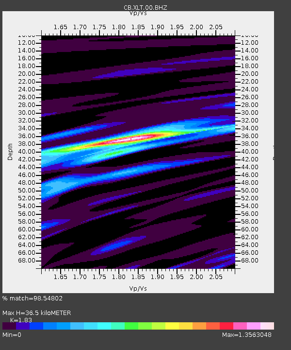
| Estimated Moho Depth: |
36.5 km |
| Estimated Crust Vp/Vs: |
1.83 |
| Assumed Crust Vp: |
6.459 km/s |
| Estimated Crust Vs: |
3.53 km/s |
| Estimated Crust Poisson's Ratio: |
0.29 |
|
| Radial Match: |
98.54802 % |
| Radial Bump: |
257 |
| Transverse Match: |
94.09683 % |
| Transverse Bump: |
377 |
| SOD ConfigId: |
2973751 |
| Insert Time: |
2018-10-09 06:08:55.669 +0000 |
| GWidth: |
2.5 |
| Max Bumps: |
400 |
| Tol: |
0.001 |
|

Signal To Noise
| Channel | StoN | STA | LTA |
| CB:XLT:00:BHZ:20180123T09:40:58.830015Z | 15.276788 | 1.087483E-5 | 7.118532E-7 |
| CB:XLT:00:BHN:20180123T09:40:58.830015Z | 10.380817 | 4.4979083E-6 | 4.3329038E-7 |
| CB:XLT:00:BHE:20180123T09:40:58.830015Z | 12.8178005 | 3.816043E-6 | 2.977143E-7 |
| Arrivals |
| Ps | 4.9 SECOND |
| PpPs | 15 SECOND |
| PsPs/PpSs | 20 SECOND |


