You are here: Home > Network List > XA95 - Missouri to Massachusetts Transect Stations List
> Station MM16 Lake Newton, Illinois > Earthquake Result Viewer
MM16 Lake Newton, Illinois - Earthquake Result Viewer
| Earthquake location: |
Colombia |
| Earthquake latitude/longitude: |
5.1/-75.7 |
| Earthquake time(UTC): |
1995/08/19 (231) 21:43:32 GMT |
| Earthquake Depth: |
125 km |
| Earthquake Magnitude: |
6.1 MB, 6.6 UNKNOWN, 6.5 MW |
| Earthquake Catalog/Contributor: |
WHDF/NEIC |
|
| Network: |
XA Missouri to Massachusetts Transect |
| Station: |
MM16 Lake Newton, Illinois |
| Lat/Lon: |
38.92 N/88.30 W |
| Elevation: |
165 m |
|
| Distance: |
35.6 deg |
| Az: |
342.968 deg |
| Baz: |
158.035 deg |
| Ray Param: |
0.076732 |
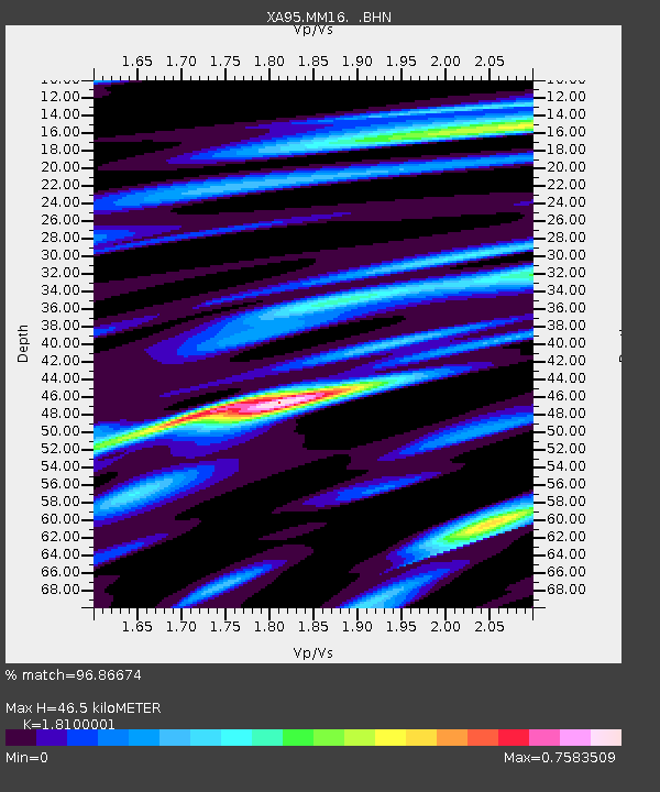
| Estimated Moho Depth: |
46.5 km |
| Estimated Crust Vp/Vs: |
1.81 |
| Assumed Crust Vp: |
6.444 km/s |
| Estimated Crust Vs: |
3.56 km/s |
| Estimated Crust Poisson's Ratio: |
0.28 |
|
| Radial Match: |
96.86674 % |
| Radial Bump: |
324 |
| Transverse Match: |
73.7266 % |
| Transverse Bump: |
400 |
| SOD ConfigId: |
6273 |
| Insert Time: |
2010-02-26 17:54:57.311 +0000 |
| GWidth: |
2.5 |
| Max Bumps: |
400 |
| Tol: |
0.001 |
|
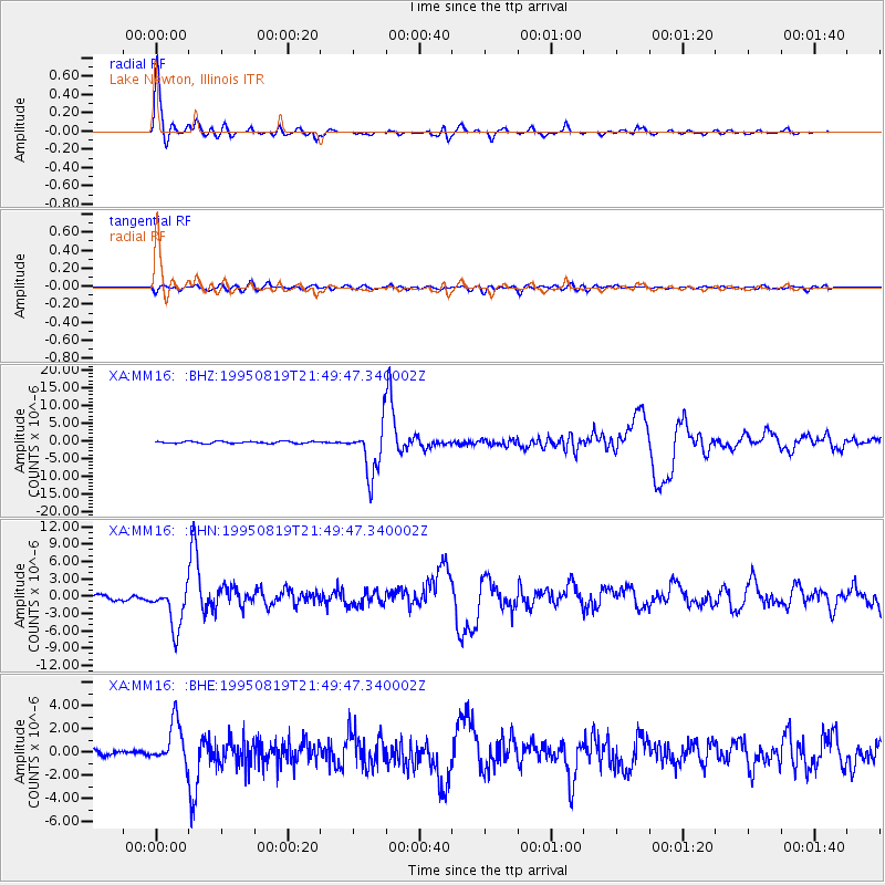
Signal To Noise
| Channel | StoN | STA | LTA |
| XA:MM16: :BHN:19950819T21:49:47.340002Z | 9.86082 | 3.7372972E-6 | 3.790047E-7 |
| XA:MM16: :BHE:19950819T21:49:47.340002Z | 9.1135645 | 1.8586933E-6 | 2.0394802E-7 |
| XA:MM16: :BHZ:19950819T21:49:47.340002Z | 24.922329 | 7.084128E-6 | 2.8424822E-7 |
| Arrivals |
| Ps | 6.3 SECOND |
| PpPs | 19 SECOND |
| PsPs/PpSs | 25 SECOND |


