MM16 Lake Newton, Illinois - Earthquake Result Viewer
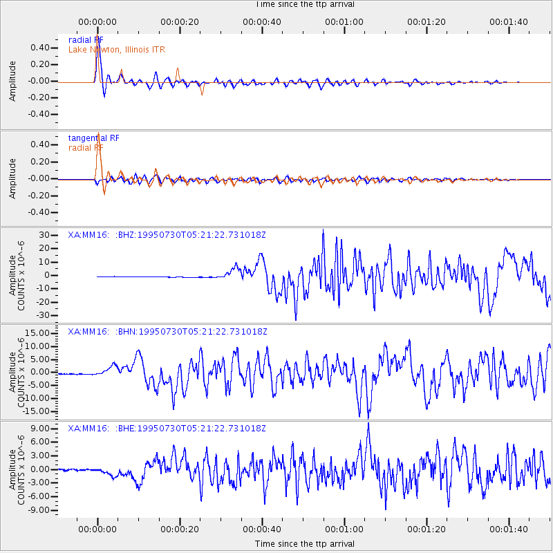
Earthquake location: Near Coast Of Northern Chile
Earthquake latitude/longitude: -23.4/-70.3
Earthquake time(UTC): 1995/07/30 (211) 05:11:23 GMT
Earthquake Depth: 47 km
Earthquake Magnitude: 6.6 MB, 7.3 MS, 7.2 UNKNOWN, 8.1 MW
Earthquake Catalog/Contributor: WHDF/NEIC
Network: XA Missouri to Massachusetts Transect
Station: MM16 Lake Newton, Illinois
Lat/Lon: 38.92 N/88.30 W
Elevation: 165 m
Distance: 64.2 deg
Az: 344.478 deg
Baz: 161.623 deg
Ray Param: 0.058972303
Estimated Moho Depth: 26.0 km
Estimated Crust Vp/Vs: 1.64
Assumed Crust Vp: 6.444 km/s
Estimated Crust Vs: 3.935 km/s
Estimated Crust Poisson's Ratio: 0.20
Radial Match: 97.4393 %
Radial Bump: 347
Transverse Match: 89.0989 %
Transverse Bump: 400
SOD ConfigId: 6273
Insert Time: 2010-02-26 17:54:58.282 +0000
GWidth: 2.5
Max Bumps: 400
Tol: 0.001

Signal To Noise

ChannelStoNSTALTA
XA:MM16: :BHN:19950730T05:21:22.731018Z13.5208192.0639852E-61.5265239E-7
XA:MM16: :BHE:19950730T05:21:22.731018Z6.26152858.886214E-71.4191765E-7
XA:MM16: :BHZ:19950730T05:21:22.731018Z25.8479254.6914283E-61.8150116E-7
Arrivals
Ps2.7 SECOND
PpPs10 SECOND
PsPs/PpSs13 SECOND