You are here: Home > Network List > G - GEOSCOPE Stations List
> Station HDC Heredia, Costa Rica > Earthquake Result Viewer
HDC Heredia, Costa Rica - Earthquake Result Viewer
| Earthquake location: |
Gulf Of Alaska |
| Earthquake latitude/longitude: |
56.0/-149.1 |
| Earthquake time(UTC): |
2018/01/23 (023) 09:31:42 GMT |
| Earthquake Depth: |
25 km |
| Earthquake Magnitude: |
7.9 Mww |
| Earthquake Catalog/Contributor: |
NEIC PDE/us |
|
| Network: |
G GEOSCOPE |
| Station: |
HDC Heredia, Costa Rica |
| Lat/Lon: |
10.00 N/84.11 W |
| Elevation: |
1154 m |
|
| Distance: |
67.9 deg |
| Az: |
105.546 deg |
| Baz: |
326.715 deg |
| Ray Param: |
0.056644265 |
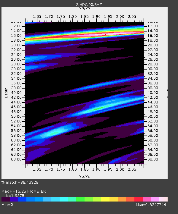
| Estimated Moho Depth: |
15.25 km |
| Estimated Crust Vp/Vs: |
1.94 |
| Assumed Crust Vp: |
6.597 km/s |
| Estimated Crust Vs: |
3.405 km/s |
| Estimated Crust Poisson's Ratio: |
0.32 |
|
| Radial Match: |
86.43328 % |
| Radial Bump: |
400 |
| Transverse Match: |
81.061 % |
| Transverse Bump: |
400 |
| SOD ConfigId: |
2973751 |
| Insert Time: |
2018-10-09 06:09:22.204 +0000 |
| GWidth: |
2.5 |
| Max Bumps: |
400 |
| Tol: |
0.001 |
|
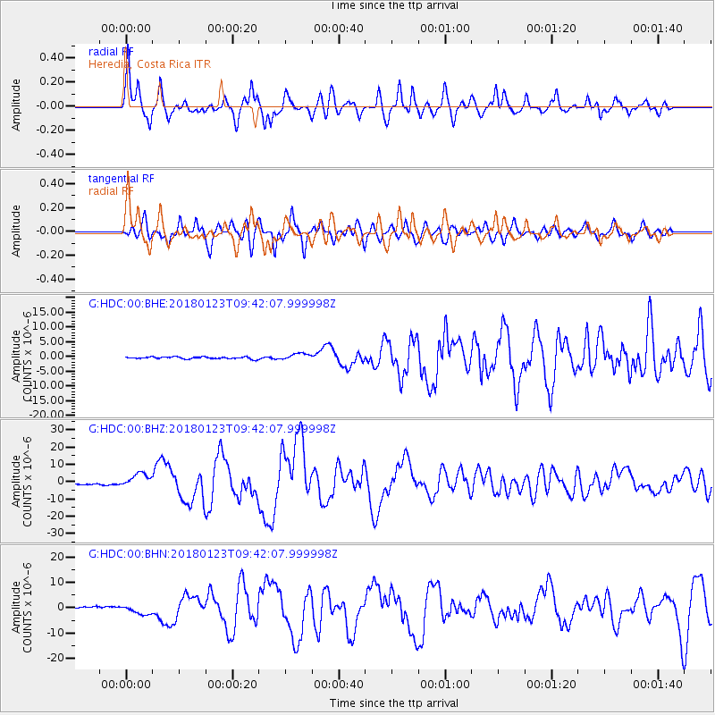
Signal To Noise
| Channel | StoN | STA | LTA |
| G:HDC:00:BHZ:20180123T09:42:07.999998Z | 10.257684 | 4.211522E-6 | 4.1057243E-7 |
| G:HDC:00:BHN:20180123T09:42:07.999998Z | 5.465613 | 1.9324664E-6 | 3.535681E-7 |
| G:HDC:00:BHE:20180123T09:42:07.999998Z | 3.419711 | 1.1517077E-6 | 3.367851E-7 |
| Arrivals |
| Ps | 2.3 SECOND |
| PpPs | 6.5 SECOND |
| PsPs/PpSs | 8.8 SECOND |


